The stone is a mirror which works poorly. Nothing in it but dimness. Your dimness or its dimness, who’s to say? In the hush your heart sounds like a black cricket. (Simic 1989, 17)
While looking over the blueprint of the windmill he designed to pump the water that flooded the mines of the Harz region,1 Gottfried Wilhelm Leibniz (1646–1716) probably wondered whether he would be more successful in draining the mines if the mountains were transparent. He envisioned the production of three-dimensional models that, combined with the chorographic maps of the zone, would provide a view of territory articulated beyond administrative boundaries (Hamm 1997, 84). Thus, besides contributing to the understanding of the geophysical environment of mines through his (failed) machines, Leibniz helped to establish a new approach to mines as laboratories of Nature that could be replicated in man-made, artificial ones. Fictions of Nature’s workshop provided German scholars with the rationale for presenting mines as the right sites for the discovery of the true structure of the Earth. However, the results of this seeming vindication of mines and miners’ knowledge were ambiguous: whereas scholars defended the mines as places for the production of knowledge about the Earth (Hamm 1997), they also considered miners’ knowledge somewhat unreliable, dimly empirical, and not adequately articulated.
Looking to the king’s support, savants such as Leibniz and Johann Gottlob Lehmann (1719–1767) saw in a highly centralized administration the possibility of eliminating the hindrances and criticisms of local administration and local knowledge, which would allow them to freely explore and implement their theories beyond administrative borders and, hence, attain a continuous, “transparent” picture of the inside of the Earth. They were rather skeptical of the potential benefits of local rules and practices to an extensive understanding of the geology of a region. Moreover, their approach tended to blur the epistemic impact of local practices, reducing manpower to raw force.2 This was not just eighteenth-century philosophers. Historians such as Wakefield, although committed to a re-evaluation of non-academic mining knowledge, ultimately relied on local actors’ social class, cosmopolitanism, and academic background to ascertain their reliability.3
One of the obstacles that hinders considering non-academic knowledge as fundamental to the disciplinary constitution of knowledge is the epistemological and methodological limitation of the focus on technological innovation as the main factor to explain the successful development of industrial and regulatory ventures during the eighteenth century.4 An alternative perspective can be discovered by looking at the material conditions and practices that made room for the continuity and stabilization of a specific activity, such as mining. Focusing on mundane practices highlights the contingency of our categories,5 but also the inescapability of the relational world they unfold in and make occur. Analyzing the processes that lead to specific entanglements between practices and materials—by which practices affect materials, and the scarcity or availability of these allow new practices to emerge or old ones to be transformed—helps us better understand the historicity of their dynamic aspects. Manuel De Landa (2000) has given us insights on how this dynamic coalescence is determined by energetic demands, the accumulation of forms of knowledge, data, skillsets, and mechanisms of decision-making. From this perspective, the environment is a practice; or better, (an occurrence of) a set of dynamic relational practices. It is also unstable enough to be constantly harnessed by “mechanisms of sedimentation” that tend to stabilize the ontologies it produces. Mechanisms such as legal definitions, theological interpretations, and externalized memories (Leroi-Gourhan 1964) pave the way to routinization and crystallize the relations that they sustain and which sustain them.6
Routine is a basic feature that allows for the transformation of an economy of agglomeration into an economy of scale.7 The subsequent intensification of energy consumption is connected to an increasing determination of practices: and the more determined they are, the harder they are to change and adjust; contingent connections became irreversible (This is probably what gives the Anthropocene, as Wendt defines it, its gloomy or fearful appearance). This process gains momentum and complexity—maybe even texture—with the generalized use of technologies and information, and strategies for linking information and materials to expectations and meanings. These last, so-called “soft technologies” serve two kings: they help to visualize and stabilize. We can locate them as tools for making some property emerge or sustaining its meaningfulness. In this chapter, I argue that the kind of entanglements produced by the specific demands of depicting mines in Nueva España produced an environment in the sense mentioned above: as an occurrence of a set of relational practices. And we cannot understand further bifurcations and unfoldings of the Anthropocene without taking into account the way these soft technologies helped to sediment “ways of dealing with,” as well as how the conflicts these technologies helped to shape are ultimately erased in the process of stabilization.
Mining as a Philosophical and Collective Endeavor
The technological, economic, and social system constituted by the Harz mining complex rested on a weak and hard-to-attain equilibrium that required the participation of financial investors, manpower, water resources, and water pumps. This ecological structure was pivotal in defining not only what counted as essential knowledge, but also the ways in which specific knowledge about the Earth could only be attained by chunking information together from a diversity of fields and experiences.
Mining in Nueva España faced the same weaknesses as in Germany: a shortage of manpower, differing rule sets, shortages or excesses of water, and difficulties in dealing with specialized workers. However, mining in Nueva España was deployed in the midst of the eighteenth-century social unrest and uncertainty. Authors such as Brading (1971) have argued that the enormous success of Spanish colonial mining during the eighteenth century was due to organizational and technological improvements.
From my perspective, the process was much more complex and by no means a direct result of the set of measures taken by the visitador José de Gálvez Gallardo (1720–1787) between 1765 and 1771.8 Opening mines in the fringes of the northern territories of Nueva España was a strategy of colonization that lured new settlers and, thus, created minimal conditions for stable border villages and military posts. Prospecting was crucial to these ends. But, of course, neither the geology nor the political sociology of the colony was homogeneous. It was difficult to predict when and whether the strategy would succeed. Moreover, it was difficult to make law an instrument for enforcing stability in mining without a previous basis upon which to assess (in economic and epistemic terms) what a proper, profitable, and sustainable mine would look like. Focusing on the lode led to a particular way of understanding the inner structure of the Earth and how to profit from it, a way tied in with the specific practices of abstracting and contextualizing information.
Different narratives traversed mines, requiring the unfolding and projection of different notions of time and space, position and direction, structure and content. This was partially attained through illustrations by means of a long-standing tradition of biblical accounts of Divine Creation (Magruder 2009). Many eighteenth-century miners would have probably been more or less familiar with some of these accounts and depictions of the Earth’s structure. At the end of the seventeenth century, as mentioned above, philosophers successfully transformed mines into laboratories and located their notions of the natural history of the Earth on more empirical grounds (Hamm 1997). But this empirical approach ran parallel to the production of new and more conceptual strategies for ordering and circulating data. Thus, Rudwick (1976) has shown in his seminal work that visual information in the geological field evolved, influenced by technological and economic constraints, into more abstract and conceptual forms that printing could spread widely.
A common visual language, however, depends not only on the circulation of printed materials; commonality also emerges from the consolidation of visual requirements in strategic fields alien to the disciplinary corpus. Rudwick stressed that the geological map evolved gradually, and that the first steps of the process took place in social contexts with utilitarian goals like mining and surveys (Rudwick 1976, 159–160). But when he looked around to identify the practical and cognitive tradition that paved the way for the epistemic framework that supported attempts to put three-dimensional information in a plane, he paid little attention to manuscript maps. Halfway between geological maps and geological sections, manuscript mine maps provide a less structured starting point. They offer a more collective approach and maybe a less linear narrative. This is, in part, because they were understood as the result of a common matrix of problems and a common language, and intended to circulate in a range of spaces of discussion. Figuring out the underlying structure of the Earth was, of course, a collective endeavor in many ways.
A surveyor and drainer, William Smith (1769–1839) based his stratigraphic principles on a transversal section drawn by the miner John Strachey (1671–1743) and published them in 1719 in the Philosophical Transactions of the Royal Society (Strachey 1719). Strachey’s work was deeply connected to the industrial development of Somersetshire (Fuller 1969). Relying on collective memory and knowledge made possible the production of a sophisticated connection between the position and the direction of veins as that provided by Strachey.9 His now-famous engraving of the coal mines of Mendip (Fig. 9.1), allegedly the first that represented the mineral strata, is a wonderful example of the kind of knowledge a miner had in those days and lands,10 and of how the visual display of all that information provided both explanations and prescriptive rules for imagining and managing (a small portion of) the inside of the Earth.11 Moreover, his account and explanation of the order in which coal veins were regularly found in a defined area showed how collective knowledge made it possible to transform local knowledge into more general knowledge.
Collective knowledge also provided the basis for Lehmann’s study on the stratigraphy of mountains.12 To describe the regular disposition of the geological layers in different—but fairly close—areas, Lehmann trusted the narratives of mining workers, whom he acknowledged as the authors of important discoveries, the source of innumerable questions (Lehmann 1759, 5), and the creators of a specialized and rich vocabulary to refer to the structure of mines and the contents of the earth (Lehmann 1759, 308ss).
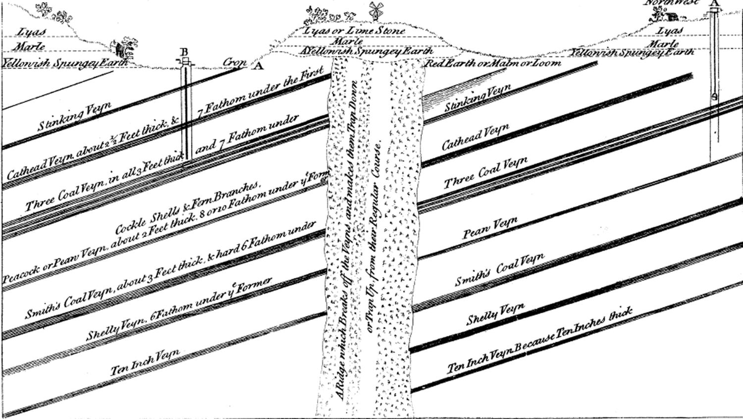
Fig. 9.1: John Strachey engraving of the coal mines of Mendip (1719).
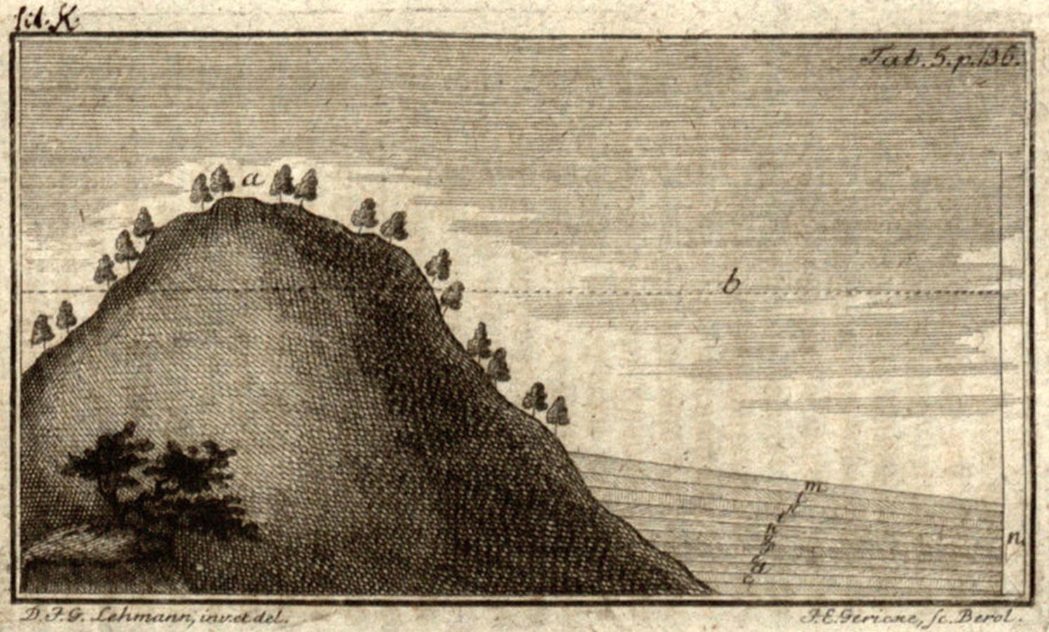
Fig. 9.2: a, primitive mountain; b, level of waters after the Deluge; c, d, e, f, g, h, i, k, l, m, layers or strata caused by slowly sedimentation. (Lehmann, Versuch einer Geschichte von Flötz-Gebürgen. Berlin, 1756, 136. Universitätsbibliothek Heidelberg, (http://digi.ub.uni-heidelberg.de/diglit/lehmann1756/0223).
It was due to their experience that we recognized the different geometries that distinguish the mines of primitive mountains—characterized by veins [filons], that is, perpendicular (or inclinés à l’horizon) strata (Lehmann 1759, 233–234)—from those of a secondary, post-deluge stage—layered mines, horizontal strata (Fig. 9.2).13
The works by Strachey, Smith and Lehman exemplify the extent to which producing these geometries was a collective endeavor, and so they help us to understand how political, orographic, and utilitarian constrictions also instilled epistemic values that fostered and oriented the emergence of these underground geometries. However, we still need many more insights into the connections between the practical endeavor of mining and the increasing complexity of mining maps as tools for ordering and producing the mine environment.
To consider this, it is worth exploring the different (visual) narratives which preoccupied mines and miners in Nueva España during the century that separates Strachey’s work from Smith’s. Many of the eighteenth-century Nueva España mining maps were produced as part of the legal file of the mine; that is, to register it as a property or resolve some litigation that threatened ownership. They were produced by maestros, practitioners and surveyors with very different backgrounds, but who faced similar problems as regarded the function they attributed to the representation and the structure of the mine and, in some cases, of the soil, as they imagined it to be. Analyzing them will help us understand the role of peritos (mining experts) and surveyors and changes in how they conceived and depicted the mountains’ innards.14
Three factors determined the evolution of these maps: the growth of the mines, local regulation on mining, and the custom of solving disputes about property in the courts which made it necessary to understand the structure of the veins to overcome legal and economic challenges. Although the law that ruled mining exploitations in the Spanish colonies was general, local variations proved important to the evolution of these maps. In Peru, miners were forced to stop their development as soon as they reached the boundaries of a mine owned by another miner or company, but miners in Nueva España could pursue a vein as far as they were able, even if they entered another mine, provided that they would give a share to the owner.15 This implies that, in cases of contention, the owners had to show they were pursuing the main vein of their property and that they knew the kinds of connections among the several veins. In most cases, they also had to demonstrate awareness of water resources and that they were not consuming the water needed for the nearest villages to survive
Since the early times of the Spanish invasion, mines were depicted basically as sketches to visualize not just the position of a mine but also the shared resources and common goods (roads, rivers, etc.) that surrounded it, as well as the kind and number of settlements nearby (that could be affected by it). Thus, a mine’s juridical and economical natures were captured at first sight. However, because of this juridical nature, how location was established and the accuracy of position became crucial—hence the importance of who did the measuring and how it was done. In the process, the challenges of measuring and depicting became a sign of the seriousness of the trade; at the same time, the series of things that entered the map in connection with the mine were increasingly marked by economical and/or strategic importance. These maestros longed, in visual terms, for an abstraction closely related (even with three-dimensional information) to the local place—just as Leibniz did when he imagined transparent models of the mountains. In the long run, I will argue, these challenges would shape the epistemological approach to the mining development as a complex system, mainly by selecting and highlighting the kind of knowledge that was considered useful and worth depicting in different circumstances.
Competing Grounds: Money and Mining in Nueva España
The insides of high mountains were rather unarticulated spaces during most of the eighteenth century, in at least two ways. First, they played the role of primeval spaces, topos, in relation to which the structure of more neatly organized spaces could be explained. This was the role they played in Lehmann’s work, which linked the production of stratigraphic order to the production of heterogeneous content, signaling a historical path in which the constant action of Nature transformed simple structures into composed ones; thus, while allowing the persistence of ordered strata, it increased the complexity of the system. By approaching the history of the Earth from the point of view of its increasing heterogeneity, Lehmann had to identify the beginning of his historical series, that is, the “primitive” spaces where homogeneity could be proven. These spaces were the highest mountains,16 the comparative term for evaluating variability.
Second, as we shall see, for most of the miners of Nueva España, a mountain was internally undetermined. They had no expectations about a stable and recurrent structure in it and no narratives about the function of its layers; and giving it an inner structure was not an intentional aim but the result of the increasing need for deploying specific geometry. Geometries sustained different notions of possession, commonality, natural history, prospecting, and foresight and paved the way for different presents and futures.
Before discussing the changes undergone by these geometries and the consequences of these changes, let us first approach the question of the many knowledges, practices and interests behind the claimed geometrization of the underground mines.
During the eighteenth century, the Viceroyalty of Nueva España increased the number of mines in all of its dependencies (see Fig. 9.3). Besides the traditional zones, such as Guanajuato, Pachuca, and San Luis de Potosí, new mining exploitations emerged in the newly conquered territories of Durango and Chihuahua starting in the early 1700s and in Sinaloa in the last third of the 1700s (Mendizábal 1980, 56). Mining exploration was part of the strategy of colonization, since the promises of wealth attracted people who would help create stable settlements. Success in establishing these settlements was uneven. Most were quite ephemeral since they were initially composed of a floating work force, many of whom were catadores (vein-seekers) in search of an opportunity for real business and specialized workers who would move as soon as they heard of a richer vein where they could earn a better living.
Typically the minero, or owner of the mine, was formerly a catador and often was also a miner lucky enough to discover a vein. This was the first step to becoming an owner, although the chance of doing so, despite the intended equanimity of the law,17 depended on the availability of capital to invest in the venture. Such capital was almost nil in the case of Amerindians, who almost immediately had to sell a new mine to a wealthier proprietor. Hence, for many indios, the discovery of a mine was an opportunity not for a sudden and dramatic change in social status but for a substantial improvement in their economic well-being.
Of course, the law protected the rights of those who truly endeavored to discover new mines since exploitation implied great profits for the crown. But these entrepreneurs had to deal with rogues who pretended to have discovered a vein just to claim the profits of their neighbor. Besides, there were important rewards for whomever was registered as the first discoverer of a mine. So the catador had to have certain knowledge and manage his scarce resources adequately before venturing to register a vein.
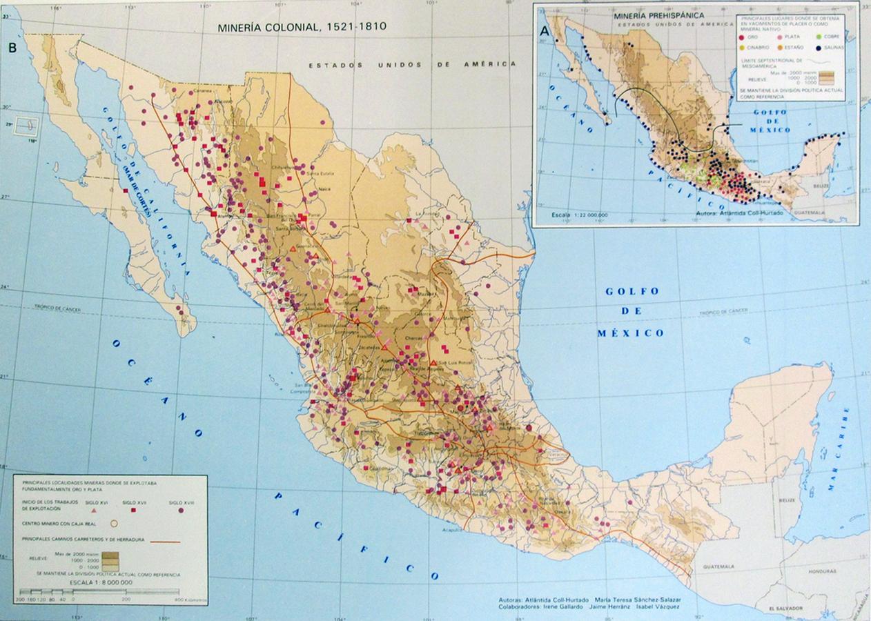
Fig. 9.3: Map of the Mexican mines during the Spanish Empire by Atlántida Coll-Hurtado (UNAM-IIG, 1990). Round dots indicate eighteenth-century mines. (Courtesy of the UAM-Cuajimalpa Library.)
The first thing he had to know about was, of course, minerals. He was supposed to know how they looked, how to identify whether a vein would be a rich one, and whether the minerals were going to be more or less pure. For the miners, especially the barreteros (blast-hole experts), this knowledge was financially crucial since they were paid in kind (as a privilege),18 and when the purity of the metal fell or it became scarce, they migrated to other mines.
Rules about mining recognized all these capabilities, and they were able to ensure a kind of fairness by designing a fine-grained protocol and geometry that transformed conjectures and signs into proofs and ontologies. Thus, the first thing a mine discoverer had to bring to the register in Nueva España was a sample of the mineral with clear directions about where it had been found. The catadores also had to dig at least three estados19 to prove that they really intended to exploit a new mine, that there was a vein, and that they were not just pretending to have found one (Gamboa 1761, 103, 105, 125). But, of course, landscape and geological features of the terrain imposed differences in ways of living and hence in the ways knowledge was used, exchanged, negotiated, and transferred.
Since the orography was very rocky and rough in some places, such as Zacatecas and Chihuahua, and some of the northern territories were sparsely occupied, it was usually Amerindians who provided—by means of missionaries and priests—the first news about a vein in those fields (Mendizábal 1980, 43). These people did not become owners of a mine nor were they forced to work in it, but they had many ways of making a living from mining. As far as we know, a good number of buscones occupied abandoned mines until they emptied most of them. But this was not a planned activity that could be projected upon the future as a rationalized industry. Native miners in the North hollowed the insides of the Earth with an apparent sense of contingency that did not leave much room for thinking about structural continuities, fostering an ephemeral economy.20 On the other hand, experienced and wealthy miners such as Juan Lucas de Lassaga could plainly deduct from the richness of these scattered mines, discovered and developed by “few men, without knowledge and without resources” (Lassaga and León 1979 [1774], 15), that the northwestern part of the Viceroyalty, a strip that went from the border between Nueva Galicia and Nueva España to the Presidio de Fronteras—a parallelogram 300 miles long and 80 miles wide—was a single bed or deposit. He also said that the richness and discontinuity of the placeres de oro (gold deposits) were due to the effects of the Deluge, since they were “ancient relics of the destruction and collapse of the mountains” caused by it. Since they were no more than vestiges, cautioned Lassaga, miners should not expect to find inexhaustible, long-standing gold exploitations because “they are not [proper] veins, so the ore can not reproduce in them.” By contrast, silver veins were sustainable since the elements of silver were diluted by water and then carried by it to the vein again (Lassaga and León 1979 [1774], 9); moreover, the deeper the mine went, the greater the quantity and purity of mineral.21 This geological and orographic profile had several consequences. On the one hand, it seemed to support the optimistic financial expectations for investing in the draining of flooded mines. On the other hand, the scattered pattern of the northern mines, and their distance from the administrative centers, caused social unrest and security problems affecting the circulation of currency (Sáenz Carrete 1999, 54).
In central Mexico, things were slightly different. In this area, the rights guaranteed to the Amerindians clashed with a pressing need for manpower. As the pressure increased from the 1720s on, social unrest also increased, and demonstrations against the forced draft of Amerindias to work in the mines are recorded in Tepoztlán and Pachuca-Real del Monte (von Mentz 1998, 26–27). After the expulsion of the Jesuits from the Spanish territories, social unrest worsened and working conditions also became harsher.22 Moreover, the cost of drilling increased, since most of the mines needed to be drained and different solutions were worked out to cut expenses. Thus, whereas the proportion of skilled workers (barreteros and cuñeros o picadores) and unskilled ones inside the mines was 60% to 40%, respectively, mine owners such as Romero de Terreros in the Pachuca-Real del Monte area tried to train the unskilled to do the job of skilled workers and thus increased the number of unskilled workers to the detriment of the skilled ones (von Mentz 1998, 39; Navarrete Gómez 1998, 104). Knowledge, costs, and conflict went hand in hand. This pattern of rationalization of mining management also reinforced the emergence of the administrator as the mining expert in high-profit mines, replacing the owner in controlling and designing the paths and practices that shaped the mine.23
Conflict most often extended to the underground in these regions, for there were more mines closer to each other in a less than stable territory. But, whereas proximity was the occasion for intermingling and legal intervention, it also fostered an increasing interest in the way veins “behaved.” The challenges in giving an appropriate, clear and complete representation of the path and connections between veins and mines, inherently linked to moral and financial concerns and costs, led to conceptualizing the galleries and tunnels as visualizing instruments.24
This conflictual approach came from both cost calculations and geological understanding and produced (and was in fact immersed in) a logic of classification and hierarchical organization. It is no surprise, then, that the analytical form most used for thinking of (or visualizing) mines was that of the tree, as we shall see. Not only Gamboa, but also Lassaga and Velázquez would claim this as the appropriate way of understanding geological and mineralogical activity:
[In the mountains] Nature created one or many metalliferous veins thick and fertile, from which, as from the trunk of a tree, usually branched many others, finer ones, often called fibres, that intersect and interweave in many ways.25
But, of course, mines should not be considered just from the point of view of thickness and form, but also from the point of view of justice, that is, slope. From the early 1730s, there are testimonies to miners’ discontent with the rule that imposed the same way of measuring a mine with a vertical vein, that is a filon, and one with a horizontal vein. We shall see how these miners’ position evolved from claiming the right to exploit the slope as it was infinite to arguing that the proper measure of a mine should be in relation to the angle from the vertical and the lateral slopes. This was not just an economic rationale, but a trigonometric one.
The Law of Veins: Description/Structure and Environment
In these circumstances, not only mines but maps of mines became more frequent during the eighteenth century in Nueva España. Complaints about the need for more accurate maps of mines were recurrent during the second half of the century.26 These complaints were the result of the progressive spread of a geometrical reasoning which was partly a response to legal requirements and partly an expression of a geological imagination. A chronological analysis of some of the maps and drawings done between the end of the seventeenth century and the end of the eighteenth, all of them at the National Archives of México, provides a glimpse of the kinds of problems miners, owners, and surveyors faced in Nueva España in defining the shape, extent, and inner structure of mines, and how they dealt with them.
As the drawing of the mines of San Nicolás, San Luis, San Diego, San Bartolomé, and Santa Clara y las Ánimas (1669) shows, during the late seventeenth century, the space occupied by the mines was at the same time idealized and hierarchical: A linear succession of mines connected along the same vein (though mining probably went on at different levels) drawn from a bird’s-eye view, stresses the size and the relative position of each (Fig. 9.4).
This was a perfect approach for imaging the orientation and disposition of the mines in the territory, but quite uninformative about the connections between mines. By 1735, the position of the entrances of the mines and the directions and length of the main galleries indicated a more detailed way of looking at the system comprised of a couple of mines. The mine of San Antonio in the Cerro Garibaldo (Santa Fe de Guanajuato, 1735) (Fig. 9.5), depicted and measured by Francisco González Castañeda y Alvarado, is a perfect example.27 González Castañeda was a medidor (surveyor) and supposedly knew the regulations and rules for measuring a mine. The normal procedure always began by identifying the estaca fixa. The estaca was the fixed reference from which the mine’s surface was calculated according to the law. He did not register it in the map, but he put information at the places where the catas (exploratory dig) had been done. He measured the mine from its main entrance along its whole path and displayed the measures of the 10 sections of the mine from a bird’s-eye view.
Hence, his map lacks the frame that would endow it with sound legal meaning, but we can find that frame in other maps, such as the one for the Cabrera and San Antonio mines (Santa Fe de Guanajuato, 1748).28
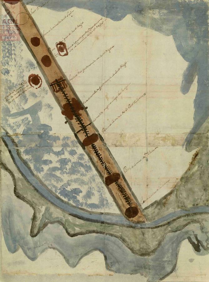
Fig. 9.4: Map of the Mines of San Nicolás, San Luis, San Diego, San Bartolomé, Santa Clara and Las Ánimas, Hidalgo, 1669. (Archivo General de la Nación, México. Mapas, planos e ilustraciones, 2247.)
Both maps, however, clearly display the mines as something without depth and as plain as roads on the surface. This way of depicting mines had an advantage of showing the intentions of the miner in the case of litigation. If the path was somehow erratic or difficult, it was clear that he was pursuing the track of the vein according to the law, but if the path was too straight in the direction of a second mine that was exploiting a rich vein, then it was clear that the first mine was a malicious one (Gamboa 1761, 297). Miners of Guanajuato were particularly fond of this way of depicting mines; at least since 1739, they had suggested that mines should be measured only at the surface, and that these measurements should not be projected in depth (Gamboa 1761, 297); the underground would remain undetermined, hence guaranteeing their right to explore and exploit the extent of the inclination of the vein as if it were unlimited.
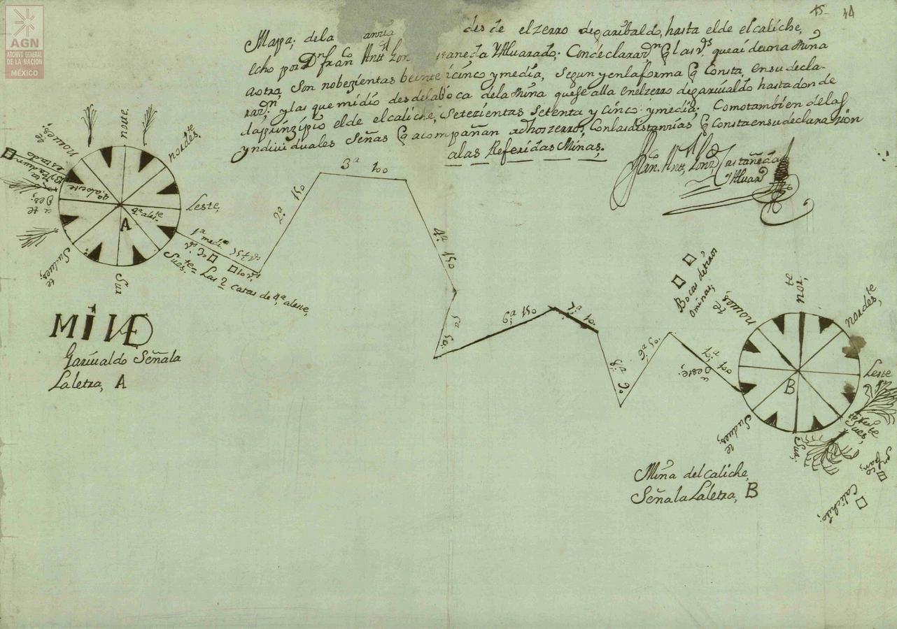
Fig. 9.5: San Antonio Mine in the Garibaldo mountain, Santa Fe de Guanajuato, Guanajuato, 1735. (Archivo General de la Nación, México. Mapas, planos e ilustraciones, 2785.)
In accordance with this rule of surface geometry, mountains were not self-contained and articulated spaces. This fit pretty well with the owners’ expectations. However, soon, the advantages of making underground volume visible became evident. During the early 1750s, a series of litigations apparently led to the consideration of new ways of depicting the growth of mines, and ensuing successive changes they underwent in legal terms, as a consequence of different surveys. Thus, the map of the mine of San Antonio de Zimapán, Hidalgo (1751), juxtaposes the measures taken in 1744 to those of 1751 to clarify the rights of the different owners over the main vein (Fig. 9.6). This strategy does not require copying a previous map, but asking witnesses for the previous measurements about the starting point of the surveying, and then translating or “reconstructing” the measurement—out of the testimonies and available data—into the new map.
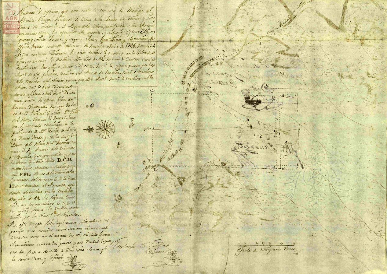
Fig. 9.6: San Antonio de Zimapán Mine, Zimapán, Hidalgo, 1751. (Archivo General de la Nación, México. Mapas, planos e ilustraciones, 1451.)
In this case, the measurements—done by the medidor Ildephonso Iniesta Vejarano—began in the estaca fixa (numbered 1 on the map), as opposed to former measurements: in 1744 it began at the entrance of the mine, or (the memories of the witnesses at the time of the first measurement differ in this point) at the rocks signaled with the number 4. This was also a surface measurement. Iniesta, as medidor and witness, apparently wanted to stress this circumstance by describing and depicting the position of the most noticeable landmarks “as [he] saw them in the field.” Consequently, Iniesta’s map mixed geometric and naturalistic styles of mapping, thus connecting the underground geometries with the surface environment.
A few years later, the inner structure of the mines became the focus of pictographic descriptions in a more decisive way. This kind of description could be more or less integrated with the environment. Thus, it could visually refer just to the geographical orientation of the mining complex, while providing textual indications of its depth in each branch or mine, and also a minute report about the wide and geological features of the vein in each case and about the general environmental conditions29 (Fig. 9.8, 9.7); or, on the contrary, show a more complex visual arrangement to define visually the underground position of the mines as well as their relative positions to the surface surroundings and the underground veins (Fig. 9.9, 9.10, 9.11).30 Shortly after these maps were drawn, the lawyer Francisco Javier de Gamboa (1717–1794) published his Comentarios a las Ordenanzas de Minas (Commentary on the Law of Mines) in 1761. In this text, he complained bitterly about the lack of skill and of scientific knowledge among the medidores or prácticos and about the fact that mines were rarely measured on the inside.31 At the time, mine measurement was still not a standardized practice: One of Gamboa’s aims was to spread the methods described in the famous manuscript on measurement of water, lands, and mines by Joseph Saenz de Escobar, whose first version dates from 1700, and the last from around 1749.32 But Gamboa’s obsession with measurement should not obscure the aims of these maps: First, to order the space, unveiling structures, arborescent dependence between the branches, and the different degrees of profitability expected in each of them, and, second, to produce a sense of unity by describing the mine as a complex yet practicable enterprise.
Despite the apparent modesty shown by the authors, the two maps mentioned above display an amazing degree of information and knowledge. Drawn by the peritos or prácticos Joseph Joaquín Barsola and Pedro Martinez, and by a medidor, Felipe de Zuñiga y Ontiveros, respectively, they reflect different backgrounds and epistemic styles. The first map is more focused on how the vein becomes more or less rich. But it also describes the mine, taking as a point of departure its main entrance (letter A in figure 9.8), situated midway on the hill, a point at which a very rich sample of ore was found. From here, the mine forked into two main galleries. One is called Santísimo Sacramento and ran northwest following the lode five varas33 deep, where two kinds of high-quality ore were found as represented in the map by the segments ABEG. The second, Nuestra Señora del Pilar, represented by AHI, ran towards the west, one and a half varas deep, with a great deal of ordinary ore. The gallery HJ went three varas upwards towards the West.
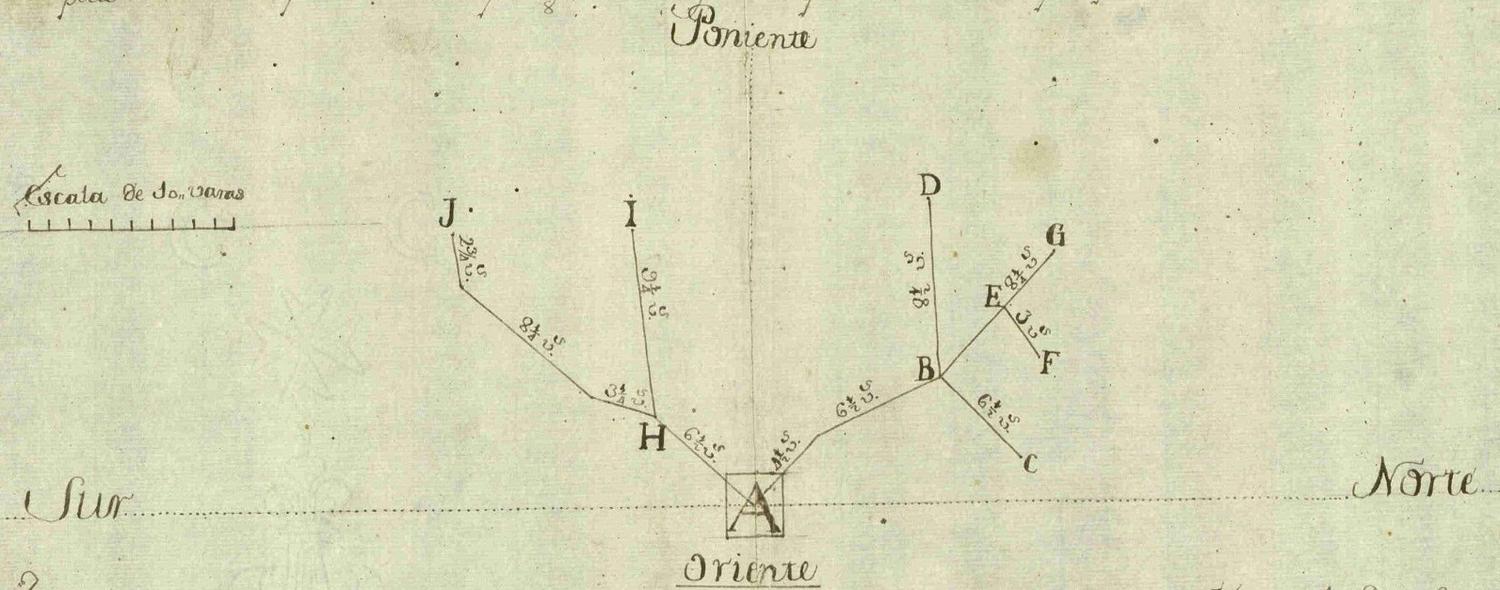
Fig. 9.7: San José (La Boladora) Mine (detail).
The Santísimo Sacramento, in turn, had three branches: BC (one vara deep) and EF, which was on the same level as ABEG, ran northeast and was rather rich. Another, BD (also on the same level as the main gallery), went west and the vein became emborrascada, that is, petered out at BD’s end. With all this information, readers could deduce that the vein had a lateral inclination towards the north—a datum that the author already gave in the legend of the map—and would even be able to calculate it. They could also foresee—to some extent, at least—what the most profitable path for drilling this mine could possibly be, since the connection, direction, hierarchies and intersections were all clear. But all this three-dimensional information was not manifested graphically.
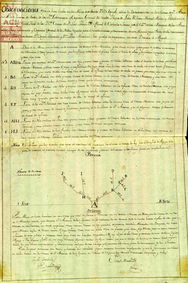
Fig. 9.8: San José (aka La Boladora) Mine, San Antonio de la Iguana Mountains, Nuevo León, 1758. (Archivo General de la Nación, México. Mapas, planos e ilustraciones, 2778.)
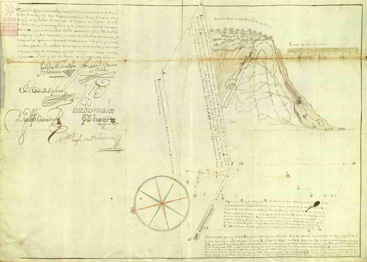
Fig. 9.9: Royal Mines of San Antonio de las Cañas, Zimapán, Hidalgo, 1759. (Archivo General de la Nación, México. Mapas, planos e ilustraciones, 4162.)
Giving the tree-like structure a three-dimensional view was the aim of the second map. It is an amazing effort to make visible how one mine (San Antonio) grew upwards, pursuing the vein, until it entered another one (San Juan Bautista). The map depicts the whole social and natural environment of the mine. In a second plane, the mountain appears. At the top of the mountain, there is a partial view of the hamlet of Real de San Antonio de las Cañas, with its main street and square, and the path that seemingly went from Real to the mines. The mountain appears sectioned. The section was done as if by taking two points in the same plane, D and L, which had been measured with a string, in such a way that the mountain was cut with a string until the cord stood perpendicular to D (which is the estaca fixa of San Antonio). This last axis is signaled by a dotted line. The same axis is part of the other lateral section, which apparently makes an angle. The section of the mountains shows the inner arborescent veins and every relevant architectural and orographic detail.
In the foreground, there is a still more abstract depiction of the relative position and connections of the underground galleries. The mountain is transparent here, and the space of representation is defined by two planes: one horizontal plane that results from the perpendicular projection of the surface measurements of San Antonio on a plane at the base of the mountain (A being the entrance to the mine), the other plane being vertical, making a right angle at the left; it represents the left section of the background mountain as defined by the dotted line from D to the base. The traces in red represent the galleries of the San Juan Bautista mine, while G is the point at which San Antonio (green line) meets San Juan Bautista. The ideal point of view for looking at the whole mining system is a high angle. But only when the background mountain is considered do we realize that San Antonio had pursued the vein upwards until finding San Juan Bautista, which was also pursuing the vein upwards. In this case, San Antonio’s owner had considered the vein as infinite, whereas the projection showed that he had far exceeded the legal terms of his property, which shrank dramatically when reduced to a plane. Not surprisingly, in 1774, Lassaga and Velázquez complained about the advantages of those miners who exploited a perpendicular vein over those who worked on one that ran inclined, claiming that the legal measures of a mine should be set once its slope was known.34
Even if both maps have obvious differences, they use the same cognitive strategy: both the conflictual meeting of the mines and the distribution of the minerals are presented as a consequence of a “natural” treelike structure; parts and dependences will always be well defined, but the shape would not be identical to any other. This produced additional consequences, as, in both cases, the singularity of the conflict and the distribution of the ore strengthened the impression that visual description helped to increase local understanding, but by no means did it allow for generalizations or, more precisely, support generalized expectations.35
Both maps acted as an epistemic instrument that helped to establish the elements that composed the unity of the description of the mine. In the second map, the attachment of the structure of the mine to the orography of the place and the surface environment unveils a change in the conception of the unity of description. We have a good example of how much this trend had evolved in the map of the Royal Mines of Tlalpuxahua (Michoacan), by two peritos, Miguel Ángel Flores and Joachín Castelaz in 1773 (Fig. 9.12).
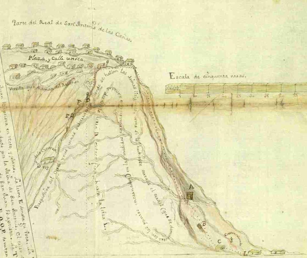
Fig. 9.10: Royal Mines of San Antonio de las Cañas (detail of the background, naturalistic style).
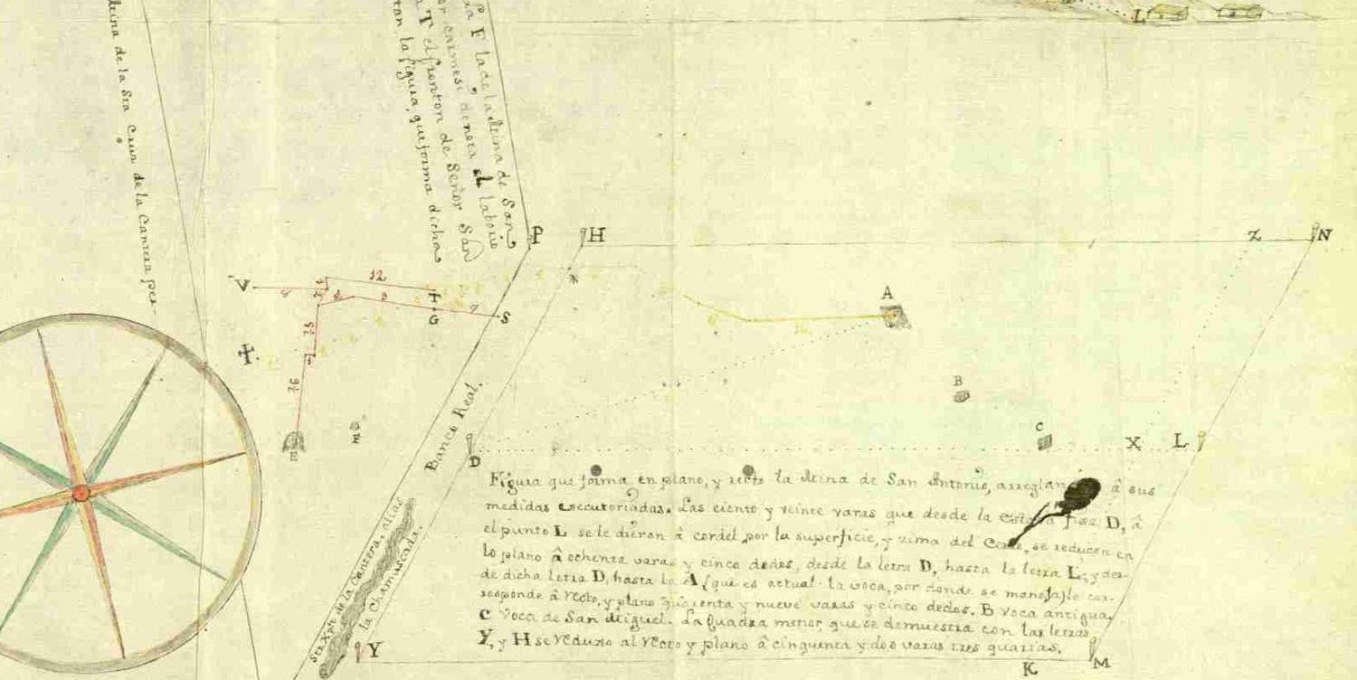
Fig. 9.11: Royal Mines of San Antonio de las Cañas (detail).
The map depicts the western face of the mountain, with the flora and the wide river that runs down the valley. It is supposed that the map should be shown first folded at the middle of the mountain, creating the effect of seeing the mountain from the side of the river opposite the mountain. When unfolded, the authors state in the legend, “it is possible to see the benefits that would result from continuing the works numbered 6, by digging deeply 50 varas more, as it is shown in the interior.” These benefits are basically the opportunity to drain several mines by almost tripling the depth of the channel on the northern side of the mountain (layer number 6), and thus being able to mine the layer numbered 15. So it is a map, and a section, and a project. Conceptually, and by means of this rather innocent contrivance, it stresses the unity of the mining complex as something that cannot be reduced to the galleries and veins. By then the miners were quite aware that roads, waters, and woods were essential parts of the mine.36
During the following decade, traditions of depicting small mines both in a naïve but naturalistic fashion (Fig. 9.13) and in a more or less complex geometrical style persisted (e. g., Fig. 9.14 and Fig. 9.15). The trend that was going to prevail was that of visualizing the mining complex within the whole mountain.
This trend was not exclusive to Nueva España. Juan Francisco Navarro’s Diseño del Cerro de Potosí (1779) is a good example of the presence of this style37 in the Viceroyalty of Peru. However, the wonderful map of the Minas del Real de Zacatecas (1789) (Fig. 9.16), drawn by Fermín de Reygadas at the request of the company mining, was based on a draft by the mine administrator Ventura de Arteaga. Its combination of perspectives signal both the extension and limits of each of the singular exploitations, the depth of the galleries, and the direction and inclination of the veins, with the names that qualified them by the nature of the mineral, as well as the several rivers that cross them. It thus captures the extent of available knowledge about the structure and disposition of the “perpendicular strata” attained by the miners in Nueva España.38 By then, due to institutional changes and the implementation of companies of mines, mining developments and “reales de minas” began to be ruled by big companies that offered a new model which tended to displace the understanding of the mining district as a set of small private unconnected exploitations. The creation of the Board of Mines (1774) also left quite a lasting mark on the conceptual use of these maps, but the main result of these successive graphical works, an enduring view of the mining complex, was a collective, agonistic, and multiple-focused accomplishment.
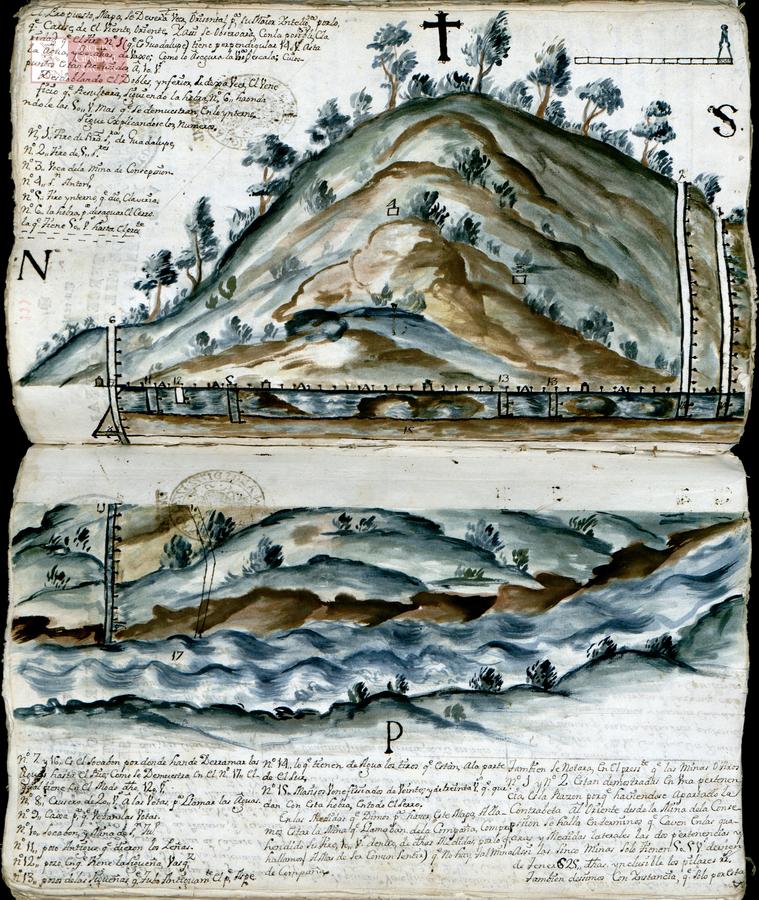
Fig. 9.12: Royal Mines of Tlalpuxahua, Michoacán, 1773. (Archivo General de la Nación, México. Mapas, planos e ilustraciones, 2746.)
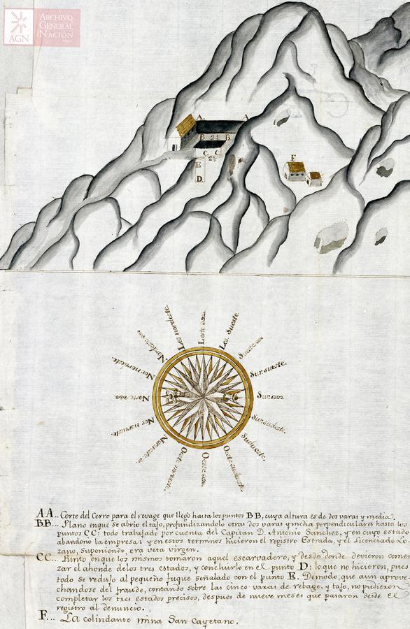
Fig. 9.13: Mines of the Señor de Zabala, Real del Catorce, San Luis de Potosí, 1783. (Archivo General de la Nación, México. Mapas, planos e ilustraciones, 2779.)
Fig. 9.14: San Cayetano Mine. Sultepec, Edo. México, 1783. (Archivo General de la Nación, México. Mapas, planos e ilustraciones, 2749.)

Fig. 9.15: San Cayetano and Santo Christo de Zabala Mines. Guadalajara, Jalisco, 1784. (Archivo General de la Nación, México. Mapas, planos e ilustraciones, 2768.)
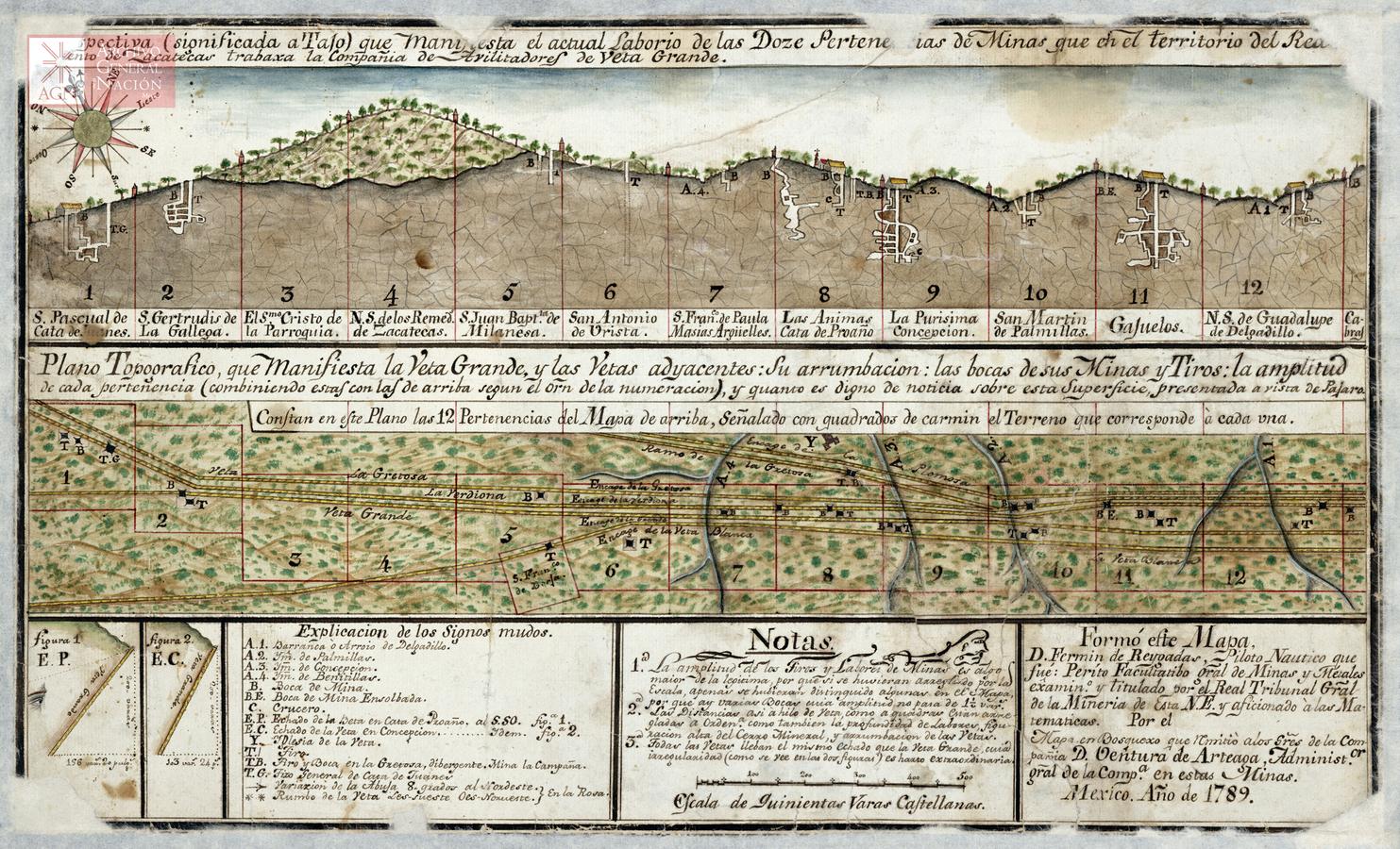
Fig. 9.16: Royal Mines of Zacatecas. Zacatecas, 1789. (Archivo General de la Nación, México. Mapas, planos e ilustraciones, 2766.)
Conclusions
Economic reasons and geometrical imagination used as foundations of notions about fairness are probably general features shared by all mining representations, as the very practice of measurement made this conceptual system its teleological end (Gooday 2004). But in the particular context of Nueva España, that is, in the context of a space where the legal framework opened the possibility of establishing an economy of knowledge by accomplishing the goal of securing imperial and local interests, manuscript mine maps produced in a not strictly standardized and formalized way acted as catalysts for the tensions surrounding mining activities by flexibly enrolling different voices, memories, projects, and fears. They did so quite locally and hence, a sense of singularity and fragmentation, even uncertainty, emerges from the reading and circulation of these documents in their time as well as today.
But they also created a way to consolidate epistemic practices and conceptual constellations not across trading zones and disciplinary fields,39 since neat differences between them did not really exist, but through spatial topographies supported by different languages, codes, and narratives. First, they constructed the relevance of the interior of the mountain as a critical effect of a historical narrative and legal record that required further visual treatment for an adequate expression, including moral and personal values. They further refined this expression by attempting to introduce the third dimension and a more holistic understanding of the mine as an entity that structured the underground and the territory. Thus, the core of the pictographic challenge they faced was not the mere and accurate depiction of the mine, but its imbrication with its surroundings, the understanding of its singular place in broader social, economic and communitarian contexts. In this sense, there is no point in dwelling on the backwardness of the measuring practices.
Instead, I have stressed the conceptual richness of these maps. Abstracting the practice of mining as one aimed at revealing tree-like structures, co-constructed with the practice of measuring, allowed the generalization of these structures as a feature of both the mountains and the mines. The maps also created social orders—after all, social prestige, despite uncertainties, was connected to the kind and part of the vein owned. In this way, experiential approaches and conceptual expectations came together, as they found a visual support that made their circulation and consolidation possible. Moreover, success in consolidating a more holistic way of perceiving and representing the relationship between veins, mines, and their environment was coupled with a more dynamic understanding of their natural history. These abstractions additionally established new connections with other topographies also based on veins and intervenios (spaces between veins) as medical ones that should be further explored.
Certainly, the description of the minute changes and achievements of manuscript mine maps helps us to understand important continuities between apparently distant styles often polarized as cutting-edge and backward or technically achieved and failed. In later maps, the intentionality of the miner, the identification of the mine design with the moral personal dimension of the owner, somehow collapses. Depicting the whole as managed by a single company diluted the agonistic approach that was inherent in the disperse and distributed structure of mining, but it also brought additional transformations. The stylization of the treelike structure in a wider space led to more squared, grid-like representations, that made the interstitial spaces look more continuous, as well as accomplishing sheath-like functions that explained the presence of the lode. On the other hand, the creation of the Board of Mining, and the emergence of an imperial project of the institutionalization of mining knowledge—represented, in the case of mining, by the Royal School of Mining of Vergara (Basque Country, 1776), the School of Mining in Almadén (1777), the Royal School of Physics, Chemistry and Mineralogy (Madrid, 1787) the Chair of Geology and Mineralogy in Royal Cabinet of Natural History (Madrid, 1788), and the Royal School of Mining of Mexico (1792)—and administrative rationalization,40 represented a further, irreversible step towards standardization of practices. These institutions tightened control over the theories that stemmed from (or still dwelled on within) non-institutionalized spaces and/or epistemic cultures,41 but, of course, they did not entirely erase the depicting practices and their consequences. Consequences such as the environmental conception of the mine were certainly settled. Thus, the above mentioned formal transformations also allowed for a more unified way of thinking—a more routinized and sedimented one—about the stratigraphic orders that populated many late eighteenth- and early nineteenth-century disciplines. But they could hardly be explained without these previous strategies that gave a local perspective and general scope to mines and mountains through visual languages.
Acknowledgements
The research reported in this paper was performed in connection to the project “Representación y modelización del conocimiento empírico” (CONACYT, CB-2012/182084).
References
Aguilar-Robledo, Miguel (2009). Contested Terrain: The Rise and Decline of Surveying in New Spain, 1500–1800. Journal of Latin American Geography 8(2):23–47.
Bowker, Geoffrey C. and Susan Leigh Star (2000). Sorting Things Out: Classification and Its Consequences. Cambridge: MIT Press.
Brading, David Anthony (1971). Miners and Merchants in Bourbon Mexico, 1763–1810. Cambridge: Cambridge University Press.
Dahlgren, Charles B. (1887). Minas históricas de la República Mexicana: revista de las minas descubiertas en los tres últimos siglos. Mexico: Oficina Tipografica de la Secretaria de Fomento.
Edgerton, David (2007). Creole Technologies and Global Histories: Rethinking how Things Travel in Space and Time. History of Science and Technology 1:75–112.
— (2010). Innovation, Technology, or History What is the Historiography of Technology About? Technology and Culture 51(3):680–697.
Fuller, John GCM (1969). The Industrial Basis of Stratigraphy: John Strachey, 1671–1743, and William Smith, 1769–1839. The American Association of Petroleum Geologists Bulletin 53(11):2256–2273.
Galison, Peter (1997). Image and Logic: A Material Culture of Microphysics. Chicago: University of Chicago Press.
Gamboa, Francisco Xavier de (1761). Comentarios a las ordenanzas de minas…. Nabu Press.
Gooday, Graeme (2004). The Morals of Measurement: Accuracy, Irony, and Trust in Late Victorian Electrical Practice. Cambridge: Cambridge University Press.
Hamm, Ernst P. (1997). Knowledge from the Underground: Leibniz Mines the Enlightenment. Earth Sciences History 16(2):77–99.
Holtorf, Cornelius (2002). Notes on the Life History of a Pot Sherd. Journal of Material Culture 7(1):49–71. URL: http://dx.doi.org/10.1177/1359183502007001305 (visited on 10/14/2014).
Lampland, Martha and Susan Leigh Star, eds. (2009). Standards and Their Stories: How Quantifying, Classifying, and Formalizing Practices Shape Everyday Life. Ithaca: Cornell University Press.
Landa, Manuel De (2000). A Thousand Years of Nonlinear History. Cambridge: MIT Press.
Lassaga, Juan Lucas de and Joaquín Velázquez de León (1979 [1774]). Representación que a nombre de la minería de esta Nueva España hacen al rey nuestro Señor. facsimilar. Sociedad de Ex-Alumnos de la Facultad de Ingeniería.
Lehmann, Johann Gottlob (1759). Essai d’une histoire naturelle de couches de la Terre, dans lequel on traite de leur formation, de leur situation, des minéraux, des métaux & des fossiles qu’elles contiennent. Vol. 3. Paris: Herissant.
Leigh Star, Susan (1990). Power, Technology and the Phenomenology of Conventions: on Being Allergic to Onions. The Sociological Review 38:26–56. URL: http://dx.doi.org/10.1111/j.1467-954X.1990.tb03347.x (visited on 10/14/2014).
Leroi-Gourhan, André (1964). Le geste et la parole. Paris: Albin Michel.
Magruder, Kerry V. (2009). The Idiom of a Six Day Creation and Global Depictions in Theories of the Earth. In: Geology and Religion. A History of Harmony and Hostility. Special Publications 130. London: Geological Society of London, 49–66.
Mendizábal, Miguel Othón de (1980). La minería y la metalurgia mexicana (1520–1943). Mexico: Centro de Estudios Históricos del Movimiento Obrero Mexicano.
von Mentz, Brigida (1998). Coyuntura minera y protesta campesina en el centro de Nueva España, siglo XVIII. In: La minería mexicana de la colonia al siglo XX. Ed. by Inés Herrera Canales. México: Instituto Mora, Colegio de Michoacán, Colmex, 23–45.
Navarrete Gómez, David (1998). Crisis y supervivencia de una empresa minera a fines de la colonia: La Vizcaína (Real del Monte). In: La minería mexicana de la colonia al siglo XX. Ed. by Inés Herrera Canales. Mexico: Instituto Mora, Colegio de Michoacán, Colmex, 95–118.
Navarro García, Luis (1964). Don José de Gálvez y la comandancia general de las provincias internas del norte de Nueva España. Sevilla: CSIC.
Nickel, Herbert J. (2000). Joseph Sáenz de Escobar y su tratado sobre geometría práctica y mecánica. Un manual sobre greometría aplicada para personas no cualificadas en la materia, escrito en Nueva España alrededor del año 1700. Historia y grafía 15:241–267.
Rudwick, Martin J. S. (1976). The Emergence of a Visual Language for Geological Science 1760–1840. History of Science 14(3):149–195.
Sáenz Carrete, Erasmo (1999). Haciendas y minas: una historia de Santa María del Oro, Durango y su región. Potrerillos Editores.
Schaffer, Simon (1999). Enlightened automata. In: The Sciences in Enlightened Europe. Ed. by William Clark, Jan Golinski, and Simon Schaffer. Chicago: University of Chicago Press, 126–166.
Serres, Michel (2001). Hominescence. Paris: Le Pommier.
Simic, Charles (1989). The World Doesn’t End: Prose Poems. San Diego: Harcourt Brace.
Strachey, John (1719). A Curious Description of the Strata Observ’d in the Coal-Mines of Mendip in Somersetshire. Being a Letter of John Strachey Esq. To Dr. Robert Welsted, M. D. and R. S. Soc. and by Him Communicated to the Society. Philosophical Transactions (1683–1775) 30:968–973.
Trabulse, Elías (1981). Aspectos de la tecnología minera en Nueva España a finales del siglo XVIII. Historia Mexicana 30(3):311–357.
Valverde Pérez, Nuria (2007). La ciencia y las dimensiones del imperio español: espacios, ciencia e Imperio. In: Maquinismo ibérico. Ed. by Antonio Lafuente, Ana María Cardoso, and Tiago Saraiva. Madrid: Doce Calles, 77–98.URL: http://dialnet.unirioja.es/servlet/articulo?codigo=2591086 (visited on 10/23/2014).
Wakefield, André (2010). Leibniz and the Wind Machines. Osiris 25(1):171–188.
Footnotes
See Wakefield (2010, 188): “The mining officials in the Harz were not bumpkins. Many of them came from venerable old families and had been educated at Europe’s best universities. Some were local gentry; others, such as Harzingk, came from foreign lands.”
De Landa (2000, 90–91). Michel Serres (2001, 183) has stressed that these changes of scale imply changes in the cultural cognitive lanscape and in the conception of science. His notion of “hominiscence” deserves greater attentions on the part of the scholars who work on the consequences of the Anthropocene.
For a detailed overview of Gálvez’s accomplishments and failures during this period, see Navarro García (1964).
Strachey explicitly recognizes that his account is based on other colleagues’ knowledge, and that both mining and oral record were the source of any valuable evidence, when he states that “some say there is also another [type of vein] under the last [of the listed kind of veins in the picture], but that has not been proved in Man’s Memory” or “At Farrington they have the same veins, which, as I am informed, agree in all parts with those of Bishop-Sutton.”
Among other things, the core of this knowledge was related to the orientation and slope of the vein, the depth and distance between coal veins, and the regularity of the disposition of the successive layers of veins. Of course, this was also an abstraction that corresponded to a particular kind of soil, and one that did not fit every territory equally, especially when the mining development was in a mountain.
This is clear when Strachey compares the depth at which two mines at different places found a specific vein: “But as in fact there are dug near the same depth, it follows there must be a Trap, or several Traps down.” As the picture shows, Strachey conceived these traps as the result of “a Ridge which breaks the Veyns and make them trap down.” On the theoretical assumptions and the links behind this kind of engineering style of representing strata, see Rudwick (1976, 168–169).
Lehmann advanced the law of superposition in his 1756 book Versuch einer Geschichte von Flötz-Gebürgen [Essay on a history of the stratified mountains]; it was offered to French-speaking readers three years later as the third tome of a collection of works translated by Baron D’Holbach under the general title Traités de physique, d’histoire naturelle, de mineralogie et de métallurgie, under the specific title Essai d’une histoire naturelle de couches de la Terre, dans lequel on traite de leur formation, de leur situation, des minéraux, des métaux et des fossiles qu’elles contienent. Paris: Jean-Thomas Hérissant (1759). I quote the French edition.
See Lehmann (1759, 218): “Si je descends dans une gallerie de mine à filons, practiquée dans le sein d’une montagne, souvent sur une longueur de 100 toises, elle aura 20, 30 & même 40 toises de perpendiculaire, au lieu qu’une gallerie pareillement de 100 toises, faite sur des mines que sont par couches ou par lits, tels qu’on trouve ordinairement les charbons de terre, les ardoises, & c-aura à peine 10, 12, 15 ou 20 toises de perpendicularie. Ainsi les mines de cette derniere espéce ont communément une pente plus douce, au lieu que les mines para filos ont una pente plus roide.”
For a completely different approach to the one developed in this paper, see Aguilar-Robledo (2009) where the author analyzes the theoretical backwardness of Nueva España surveying during this period due to financial factors and a lack of regular mathematical training.
See Gamboa (1761, 213, 300). Other differences between the rules of the two colonies on p. 204.
See Lehmann (1759, 104, and section III, 235ss).
See Gamboa (1761, 23–24).
Mine owners were aware of the advantages that barreteros took of their knowledge and, in some cases, they tried to instruct unskilled workers in this trade who would not ask to be paid in kind, von Mentz (1998, 39).
An estado was a measure equivalent to the average man’s height.
See, for example, Dahlgren (1887, 218) about the Lomo de Toro mines, where—“as happened in many mines after the Independence”— native miners looking for short-term profit and working without a system literally hollowed the mine, destroying pillars and causing its collapse.
Miners did not believe in the law of diminishing returns precisely because economic prospects depended on geological knowledge. See, for example, Lassaga and León (1979 [1774], 9): “¿por qué no han de esperarse metales de crecidas leyes en las labores hondas y principales, encontrandose casi en la superficie, y siendo un axioma inconcuso en la Minería, que estos preciosos frutos se crian con maior madurez, y abundancia á una justa profundidad? Podría decirse, que los metales de las labores altas son provechosos, porque no reportan el crecido costo del desague; pero tampoco se sacan de tan buena ley, y en tanta copia, como de las labores profundas. En esto hai (sic) una diferencia mui grande, como prueba la experiencia, y aun sin ella persuade la razon.”
von Mentz (1998, 27). In Nueva Vizcaya (Chihahua, Durango) several missions were transferred to the secular clergy, which implied the incorporation of Amerindians into mining work, Sáenz Carrete (1999, 55–56).
Lassaga and León (1979 [1774], 3). Lassaga and Velázquez considered loose or independent veins, those that did not fit the tree-form, to be abnormal and ill-constituted (peregrinas y mal constituídas), Lassaga and León (1979 [1774], 12).
See, for example, Gamboa (1761, prologue w/p, 231) and Lassaga and León (1979 [1774], 28). Aguilar-Robledo (2009) analyzes these complaints in connection to surveying. He stresses the high costs of surveying, which explains the lack of expertise in rural areas.
“Mapa de la [minas de San Antonio] de el zerro degaribaldo, hasta elde el caliche, echo por Dn Franco Gonzlz Castañeda y Alvarado; condeclarazn q las Vs que ai de una Mina aotra son nobezientas binte icinco y media, segun yenlaforma q consta ensu declarazn.”
Mina de San José (aka La Boladora), Sierra de San Antonio de la Iguana, Nuevo León (1758). This information appears in the text of the map (Fig. 9.9). Regarding the environmental conditions, it reads: “This mine drills down a lode that runs from East to West with a slope towards the North by the side of a hill or high Mountain called San Antonio de la Iguana, halfway its path from the summit to the base of mountain, which ends in a ravine where other mountains not so high start, and seemingly also other mineral deposits, [at this point, i. e. halfway] there is no woods, and nothing except underbrush: the above mentioned vein is embedded in the rock in some parts, and it softens in other parts, but all along it is sheathed with a blue stone or slate in both sides. At the base of the mountain, and within five leagues around, there is no stream or river; there are only, not very far away, some half-drained, little eyes of water [oxitos de agua cortos], that run totally dry during the dry season, according to those experienced and that have longtime knowledge of the place; right now these eyes only can be used for the survival of people.” (author’s translation).
Real de San Antonio de las Cañas, Zimapan, Hidalgo (1759).
See Gamboa (1761, prólogo, 206, 231).
There were at least nine drafts of this manuscript. The original is lost, but seven copies—with great differences between them, dated between 1706 and 1749—are nowadays localized and preserved. The most detailed work about the history of the manuscript and its successive copies is Nickel (2000). See also Aguilar-Robledo (2009, 34 note 19).
A vara is approximately 0.860 meters, and a yard 0.914 meters.
They also explained that if the mine has a slope of more than 45°, then the legal property of it would end before the miner was able to reach the depth at which the vein would be more fertile. See Lassaga and León (1979 [1774], 28).
See, for example, Gamboa (1761, 200–201): “considerada mas profundamente la calidad de las Vetas, se advierte la grande diversidad que ay (sic) entre ellas: por lo que unas no pueden servir de exemplo ò regla para discurrir la situacion, y curso de las otras. Y aunque esta materia toca à los Physicos, que han especulado, y observado los arcanos del Mundo subterraneo, y es de difícil comprehnsion, estando encerrada en las entrañas ocultas de la tierra; es muy propio de nuestro assunto decir las diferencias, diversos gyros, y progression de las Venas, experimentada por los Professores, y Prácticos; como que de esta misma diversidad se conoce la justificación de tomar las medidas de las Minas por todos los rumbos que se discurran mas favorables al fin: [...].”
See Lassaga and León (1979 [1774], 33ss).
This style would last for a long time in the fashion of a blueprint. See, for example, Mina de Veta Negra, Sombrerete, 1826. AGN, Mapilu.
It is worth noting that Fermín de Reygadas (ex-piloto náutico and expert in mines and metals, one of the first graduates of the Real Tribunal General de Minería) depicts the inclination of the main vein in two points—signaled in the map as EP and EC, that is, Catas de Proaño and Concepción, áreas 8 and 9 respectively. From this information he was able to determine the extreme irregularity of the vein inclination, as well as the adjacent ones, since all of them run in parallel.
I noted elsewhere that these institutions were linked to governmental secretaries or military departments and their research was oriented towards the optimization of energetic and natural resources, Valverde Pérez (2007, 92).