Chapter structure
- 19.1 Introduction
- 19.2 Navigation Techniques of the Moce Islanders
- 19.3 First Phase: Blown by the Wind
- 19.4 Navigation Techniques of Moce Islanders Phase II: First-Generation Stellar Navigators
- 19.5 Technological Change: Motoring Along
- 19.6 Discussion
- 19.7 Technological Change in Lau
- 19.8 Conclusions
- References
- Footnotes
19.1 Introduction
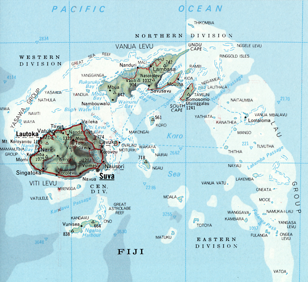
Fig. 19.1: Map of the Fiji Islands.
In 1998, I had the opportunity to travel to Fiji to assess Fijian
Moce Island, which is some 325 kilometers (172 nautical miles) from the capital of Fiji, Suva (Figure 19.1), is about ten square kilometers in size and roughly circular in shape. The Lau group extends about 250 nautical miles north to south. Moce is in Southern Lau and is one of the easternmost islands in the group. There are two villages on Moce: Korotolu and Nasau. Today, with a population approaching six hundred people, the two villages have merged. However, the architectural style of the two villages has remained distinct: the houses in Korotolu are primarily oval in shape with a single room, while in Nasau, the bure houses are rectangular with several rooms, thus reflecting historical differences in the original settlers.
According to the people of Moce, there was a group of smaller darker-skinned Fijians living on Moce when a group of people from Tonga arrived. The Tongans asked permission to stay and set up a village some distance from the original village, Nasau. About one hundred years ago a whale was beached on the reef near the Tongan village, and for months the smell of the decomposing carcass made living there unbearable. The new settlers asked permission to relocate to a site closer to Nasau and named their new village Korotolu which means third village in Fijian. The Moce Islanders estimated that the move occurred about one hundred years ago, however, Laura Thompson 1972, 136 gives the date of Leva village moving to Korotolu as 1921. Today, only the descendents of the original inhabitants are allowed to bury the dead on Moce. This was the only instance I observed where origins were relevant. There has been and continues to be considerable intermarriage between the two groups.1
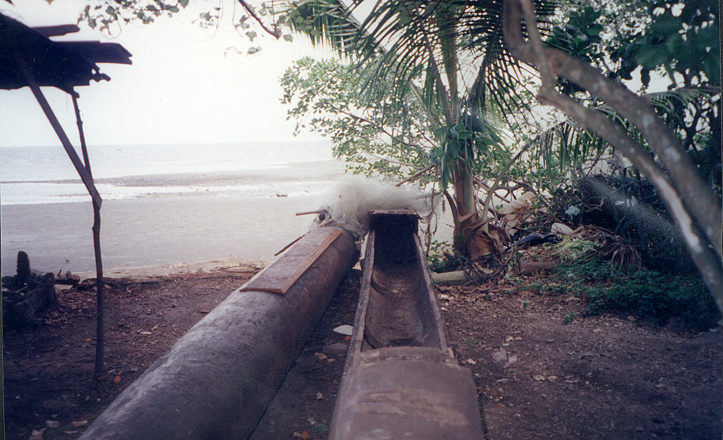
Fig. 19.2: Remains of the canoes used for the famous trip to Suva.
Near Suva, there is a group of Moce Islanders in diaspora living in a village named Korova (fourth village). In addition to being the capitol, Suva is the largest city in Fiji with a population of over 73,000 people. I conducted my preliminary inquiries into the navigation practices of the Moce Islanders in Korova. Simione Paki’s son, Semiti Cama Paki, lives in Korova and provided me with information about his father, the famous trip to Suva, and allowed me to photograph the remains of the canoes used for the voyage (Figure 19.2). The people living in Korova were very excited about the possibility of me studying Moce navigation. They were eager to have their traditions recorded.
From the information provided in Korova, I determined that the Moce islanders used
My data collection methods included interviews, informal discussions, and paying attention while I was traveling in boats. I used snowball sampling to identify individuals who potentially had knowledge about navigating. The interviews were semi-structured with a list of questions focusing on gathering demographic information, navigation skills, and experiences navigating. The interviews were conducted in English or in the Moce Island dialect. Though I have some competency in Fijian, I could not follow the Moce dialect, thus I worked with local translators. The translators often sat in on my interviews even when they were conducted in English and would occasionally interject in the
19.2 Navigation Techniques of the Moce Islanders
In 1998, my research on Moce began with interviewing Simione Paki. I went on to interview a series of men: sailors and farmers ranging in age between 54 and 84. During these interviews, I focused on the mechanics of their system of navigation, the use of
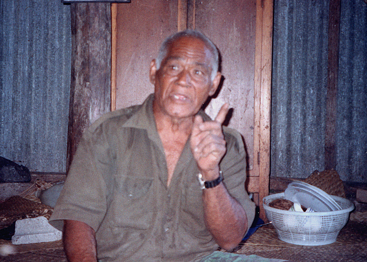
Fig. 19.3: Simione Paki
One example of a survival story was told by Johnny Rapui (~40 years old), who was sailing back to Moce when he encountered a hurricane. He cut down the size of his sail so that it would catch less wind and maintained his course to Moce. He arrived safely.
I have chosen to present the narrative of Simione Paki reconstructed from my field notes in this section. It serves as a typical example of the navigation style of the Moce Islanders including wind directions, visual markers, and knowing when to reset the sail and change directions. However, Paki’s story is unique because in the early 1990s he sailed an exceptionally long distance, from Moce to Suva, using traditional methods. Most of the men have sailed only the extent of the Lau group of islands. The difference is not only the distance, but that when sailing in the Lau group one is rarely out of sight of land, whereas the route to Suva involves stretches of many hours on open ocean.2 Paki is also unique in that he sailed weekly to other islands in the Lau group and occasionally to Tonga using Fijian canoes and using traditional methods,3 whereas the other interviewees made a few long trips a month. Paki is 72 years old.4 Today, he sails to his garden about a mile away from his home most mornings to collect vegetables for his family’s consumption. What follows is a summary of Paki’s narrative.
The trip to Suva was initiated by one of Paki’s sons, Metui. Metui thought that it would be a good financial enterprise to have traditional canoes in Suva to give tourists rides for a fee. There are no hardwood trees on Moce, thus they traveled to Oneata5 and acquired a double-hulled canoe and a single canoe for the trip. In the last week of February in 1992, by my calculation,6 on a Friday, Simione Paki, his son—Metui, and a third man set out for Suva.
They sailed to Olorua Island (west of Moce) and had originally planned to spend the night there, but since the weather was so nice, they continued. When they reached halfway between Vanuavatu Island and the reef near Tavu-na-sici, the wind was blowing from the east. They set their sail and went southeast to Totoya Island. Once Totoya was sighted, they reset their sail for Moala Island. When they reached Moala, the wind changed to east-southeast, so they changed the sail to go west towards Suva. On Sunday night, they sighted the lights of Suva, however, at that point the wind was not good. They reached a small island very close to Suva and spent a few hours there resting. The next day, they sailed on to Suva, reaching there at four in the afternoon on Monday. There the narrative ends.
After listening, I asked him questions about the details of his voyage: The entire trip took four days and three nights. Paki marked the time using a radio, which he carried in his canoe. There is no indication that keeping track of time was part of his navigation technique. His technique was to change directions when certain islands or reefs were sighted. The trio carried their own supply of food, water, and a Primus (kerosene) stove for cooking. Paki learned the route from riding on commercial boats between Moce and Suva. Again, the reason for the voyage was to take canoes to Suva as a commercial venture to offer tourists rides in Fijian canoes.
There is a second part to the story: In December 1993, Metui and a friend set sail for Suva in another double canoe. They were last sighted off Moala, but never reached their destination. A month later, their canoe washed up on Kadavu, an island south of Suva. Both Metui and his companion were presumed dead; their bodies were never recovered.
Historically, the people of Moce would make long trips to Tonga, which requires sailing for several days without sighting land, rarely to Suva.7 The wind patterns generally travel from west to east for part of the year,8 and since Tonga is east of Moce they would travel with the wind. The people of Moce estimate that they took their last big trip to Tonga in the 1950s. When asked why such trips stopped, they said that the big traditional canoes called drua were no longer being made and that the trip is not easy in a smaller boat. Sometime in the 1980s, a boat containing a Tongan man washed up on the reef. He had run out of petrol while fishing in Tongan waters and been adrift for one month. When greeted he did not respond because he thought it was another of the many hallucinations he had experienced while adrift. Eventually he was returned home to Tonga. This drift story shows that the current travels from east to west during some part of the year, too.9 Paki also made trips to Tonga in his canoe as a lay preacher. Tantalizingly, in 1998 Paki mentioned (via the translator) that he used “the star to Tonga” when he traveled to Tonga. Paki was the only Moce navigator to mention this star and during my 2003 field visit I was able to determine that he was referring to Venus. He used Venus setting in the West in the evening, which he placed at his back to go to Tonga.10
JH: When you left Moce and went out to sea and headed towards Tonga did you use the stars?
SP: We left Moce during the day. We only used the stars during nightfall in the evening: the Naivolabongi.
JH: Navolabogi?
SP: Naivolabogi.
JH: That star, is it directly over Tonga or?
SP: Yes, directly over Tonga. The Naivolabogi rises directly over Tonga. The Naivolasiga, you can see it during the evening.
JH: When it is night time the Naivolabogi is right after sunset. It is near the sun, so it is actually in the west, right? Where Tonga is in the east.
SP: I think it is directly over Tonga because it is in the path of the sun. The Naivolasiga comes in the early in the morning. The Naivolabogi in the evening.
JH: Is that the only star you use in the evening?
SP: Yes, the star that is directly behind you … in the west.
In most cases, including with Paki, the men provided information on the
only included the Sun, Moon, Venus, and possibly other visible planets, thus they only used planetary bodies and
these celestial bodies were only used near the horizon when they were rising or setting in order to find east or west.
19.3 First Phase: Blown by the Wind
The use of celestial bodies was only one part of their navigation system and given that the navigators had to be prompted to speak about it, a not so important part of their navigation system. The Moce Islanders in my first set of interviews had a tremendous knowledge of the passages through the local reefs, the currents, and the wind patterns in the Lau group. As with Paki’s narrative, the stories that they told me during their interviews12 contained detailed information such as a change in the direction of the wind or the direction from which the waves were coming (current direction) as noted by how the wavefronts broke against the hull. When they were required to change the sail, how many times they had to change the sail, and the sighting of islands and reefs, all punctuated the stories. The Moce Islanders gave the impression of having set routes for travel between the various islands of the Lau group. Included in their system are natural markers that had to be sighted before changing their sails.

Fig. 19.4: Diagram of the traditional’ navigation of Moce. The Sun, Moon and Venus were used as rough east and west markers when they were near the horizon. Drawing by Tina Gallier.
The system of navigation depended first and foremost on an intimate knowledge of the wind and current patterns along with knowledge of the locations of reefs and islands, both uninhabited and inhabited. The only
The interviewees learned to navigate as children by traveling in boats and watching the navigators. Children are included on fishing trips and inter-island trips, the adults often allow the children to help with the sailing and navigating. None of the interviewees indicated that the adults gave formal lessons in sailing, instead the children had to pick it up as they went.
The boat on which I traveled to Moce from Suva also transported about ten people returning home to Moce. While on the boat, I questioned these individuals about their knowledge of navigation and came to the conclusion that certain stars, the Moon, and the Sun were all used as part of their
19.4 Navigation Techniques of Moce Islanders Phase II: First-Generation Stellar Navigators
The second set of interviewees averaged 42 years in age, were male, and had lived primarily on Moce. They tended to have traveled many times to Suva (via government boats) to work or visit relatives. They had completed primary school and had often attended secondary school away from Moce at the school on Lakeba or one of the

Fig. 19.5: Alifereti Amani (on top) helping to repair a boat.
The second set of interviews began with Alifereti Amani, 42, which I present as a narrative typical of the younger navigators (Figure 19.5). His narrative is derived from my fieldnotes. Amani was one of the people I met on the boat to Moce and, as with most of the interviews in this group, the interview was conducted in English.
Amani described how when traveling to another island, after exiting the reef, he would place Moce at his back at the correct angle to reach his destination until Moce disappeared from view or the next island marker appeared on the horizon. Although the next island is not visible, the Moce men know its direction relative to Moce. When twilight falls, if he has not reached his destination, he picks a star that marks the direction in which he is traveling. He follows that star until he reaches his destination.
Again, after listening to his description, I asked questions to learn more about using the
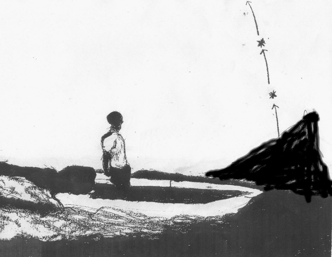
Fig. 19.6: n the new system, there is no shortage of stars in the direction they wish to go. Drawing by Tina Gallier.
The interviewees in the second set all said similar things. They spoke of their knowledge of exiting the reef, using Moce or other islands as navigation markers, and at night using stars in the correct direction as beacons. There was no mention of current and wind patterns. However, they did name the Volabogi, Volasiga, and the Sun and Moon and how they are used in navigation as rough east/west markers. They all said that they did not use a magnetic compass.
19.5 Technological Change: Motoring Along
The older men used traditional canoes with sails. The younger men originally learned to sail, but over the last two decades, the outboard motor has become common and the islanders have switched to wooden and fiberglass boats and punts. Today, there are very few traditional canoes on Moce—even Paki uses a punt with a sail.
The fact that boats are driven by outboard motors appears to have had more effect on navigation than the shape of the boats or the materials used to construct them. The outboard motor allows the boats to travel in straight lines, independent of the wind and current. The outboard motor significantly reduces the travel times because tacking is no longer necessary; in addition, with the canoes they actually shunted, which means that in order to change directions they would remove the mast from one end of the canoe and place it on the other end of the canoe. Shunting is a much slower process than tacking. In regard to navigation, this means that visual markers have come to dominate the method of the Moce Islanders. Bearings in relation to islands, reefs, and stars rather than settings of the sail and wind directions punctuated the narrative of Alifereti Amani and his contemporaries. It is the inclusion of stars in the new method which makes the Moce case unique in the Pacific where, in general, navigation methods that use celestial bodies are in decline.
I went on to learn more about the impact of the outboard motor on the use of stars for navigation in the remaining interviews. The men who use the new method consistently said that they taught themselves or “figured it out” themselves. I was startled by the narrative of an older man in his seventies who spoke of using the stars to mark his way home from Lakeba to Moce, because I had thus far concluded that only those in their forties or younger would use the new method. However, he told me that he was using a motorboat at the time, which was consistent with the connection between the use of the outboard motor and using the stars. As with the other men, he said he learned the technique of using the stars in this manner himself. In general, the outboard motor users felt that using the stars was the most obvious thing to do at night while traveling. The younger generation of navigators also told tales of capsizing and having to cut the sail in bad weather, but these were stories from their youth back when they used canoes. None of the informants claimed to have had formal naval or navigation training and did not describe their techniques nor distances in nautical terms.
The new system and the old system of navigation are admittedly inexact, but sufficient for the type of navigation performed by the Moce Islanders. Travel undertaken by the Moce Islanders in smaller crafts is limited to destinations within the Lau group—rarely is an island or the water breaking on a reef not visible during travel. Thus, the homing skills necessary for long-distance ocean voyaging are not found in the interviews.
The new method of navigation including the stars is being transmitted to the next generation through watching and doing. The children of Moce are often given command of the boats while traveling with adults and are told to keep the motor pointed towards a particular star when traveling at night. Their training is thus more of an apprenticeship of convenience rather than formal.
Once I was better able to articulate the two navigation techniques, I returned to the first set of informants and asked them how they felt about the new technique. All the men praised the fact that traveling by motorboat was much faster than sailing. A few thought the new method was bad because the motorboat users no longer paid attention to the wind and current. They explained that the drawback to relying so heavily on visual cues is that when visibility declines, such as during a storm or in fog, they get lost unless they were paying attention to the wind and current.13 It was clear that the knowledge of wind and current patterns was considered to be the most important part of navigating for the old Moce sailors. They felt that this particular knowledge should not be forgotten.
19.6 Discussion
The situation on Moce is the first case I have found of a
Of the contemporary studies of Pacific navigators,14 the majority of cases showed a loss of the celestial aspect of navigation as the navigators became more dependent upon modern navigation equipment. The authors often had to search their fieldsites for the few remaining celestial navigators. This was definitely not the case in Moce. One of the studies did mention a change in navigation technique towards a celestial one, but the circumstances did not involve a response to a change in technology: In Lewis’ The Voyaging Stars, Siona Mafi of Nomuka Island in Tonga is presented as someone who was formally trained in the use of charts and compass, but got tired of using them. He developed a celestial system by first using the
Another possible example of an ad hoc
There is a similarity between the new method of Moce navigation and navigation techniques found in other parts of the Pacific. In the late 1960s, David Lewis recorded the words of a Tongan navigator, Kaloni Kienga:
You head towards that star […] and when it has moved too high and too far to the left, you follow the next to arise from the same point on the horizon. Then the next, and the next, and so on until dawn. This we call kaveinga, the star path. Lewis 1978, 18
Kaloni Kienga only named the first star, which he pointed out to Lewis; the other following stars he did not name. Lewis found this method in use in many other parts of the South Pacific, where the location of island groups is marked by the rising and setting of a “bright” star and the course is maintained by following a chain of less prominent stars. The Fijians currently use a convenient star (not necessarily a bright one) that is not named but also use successive rising or setting stars. This technique clearly marks the beginning of a new kaveinga-like system.
The ethnography done by Laura Thompson mentions the
Why given similar traditional boating equipment across the Pacific did the Moce Islanders not have a kaveinga system before now, especially since at least one person on Kabara had such a system? Is a kaveinga system typical of long distance ocean voyaging, which the Fijians rarely pursued during the last century?
The old people before, they use to say that they use the stars as a mark when they travel at night. If there are one, two, three stars and they are bright, and are directly over an island, they are going to keep it, and they will work out just to use the stars as theircompass. (Moce Interview 01/03)
Even if they taught themselves how to navigate by the stars this does not mean that their ancestors did not navigate by the stars. In fact, most Moce navigators believed that in their grandfathers’ time, more people knew names of the stars and how to use them to navigate. The young navigators of Moce may be recreating an older Moce kaveinga-like system on a much smaller distance scale. If the new method is indeed a revival of an earlier tradition, the Moce Islanders are firmly unaware of it for all claimed to have made up the new method themselves. The Moce navigators in both sets of interviews did think that perhaps their forefathers knew more stellar names, but none connected this to a lost system of navigation that relied more heavily on celestial markers. Anthropological studies in the 1920s and 1930s do not support this view that previous generations knew more stellar names Hocart 1929; Thompson 1940. Although, neither study includes information on Moce navigation, Hocart recorded the traditions of many of the Lau Islanders, and as today, those that used the stars to navigate did not know the names of the stars. In addition, there is the question of the Tongan influence on Moce navigation. The Moce Islanders presented their system of navigation as their own; there was no distinction between the systems described by the inhabitants of Nasau or Korotolu (the two villages on Moce). If there had at one time been such a distinction on Moce, since one village is of Tongan origin, it has been forgotten.15
At latitudes of the United States—greater than thirty degrees north—people are familiar with Polaris which marks the north celestial pole. Over the course of the night, certain constellations close to Polaris are seen to circle the pole, further emphasizing the location of the north celestial pole and therefore north. Thus, most of the navigation systems we find at these latitudes utilize Polaris and constellations that allow one to find Polaris. At the latitude of Fiji—eighteen degrees south—Polaris is not visible, nor is there an obvious marker for the south celestial pole. All stars rise in the east and set in the west following the path of an arc. Given that the stars move in this manner, the obvious way to use the stars for navigation in this part of the world is to follow chains of rising and setting stars. Once the motion of the stars is understood, it is possible the theories of technique transfer or technique revival are no longer needed to explain the
Going back to the question, especially now given the understanding of how the stars move at these latitudes, why didn’t Fijians have a kaveinga-like system? It is my opinion that given the short distances Fijians traveled while sailing, a kaveinga-like system may have proved too inexact. I hypothesize that when sailing over long distances, the zigzag pattern necessary to maintain a heading under sail would average out to a line. However, for traveling short distances, traveling too far without resetting the sail may cause you to overshoot your destination. Thus, the set routes which included when to tack may have proved more accurate than following the stars. I have had no feedback on this theory with the Moce Islanders.
19.7 Technological Change in Lau
The implications of
Lauan sailors say that a mat sail is better than a canvas one for the mat allows the wind to pass through and therefore the mast is not easily strained or broken. Thompson 1940, 176
This passage is significant because it shows that introduced technologies were in Lau over sixty years ago. At that time, the Lauans were not eagerly adopting the new canvas sails, but instead tested them and found that their own mat sails better met their needs. Further:
Salvaged hardware from shipwrecked yachts is commonly adapted for use on Lauan sailing canoes. Friction hitches and simple mechanical advantages, in conjunction with simple wooden hardware, are used in the rigging of a sailing canoe. Gillett 1993, 41
This shows that the people of Lau are amenable to adapting new technology if there is a clear advantage.
On Moce, the outboard motor has a clear advantage over sailing because it has led to faster inter-island travel. The
The Moce Islanders have switched from using canoes to using punts and boats. Though I did not question the navigators about the pros and cons of the change in boats, I imagine that the roominess of the new boats is an advantage. An outboard motor easily fits to the back of the punts as opposed to the tapered end of the canoes. Interestingly, Lewis states that the Fijians around the Koro Sea (west of Lau closer to Viti Levu) called their canoes waqa ni tagane—boats of men (boys), whereas the punts were called waqa ni yalewa, predictably, boats of women (girls) Lewis 1978, 110. This division may imply that the Fijian canoe is regarded as more manly than the punts, or that women preferred to travel in punts. I found no such distinctions on Moce or other references that would shed light on this designation.
Another author to comment on the adoption of
There has been a marked effect on the regular use of traditional, Fijian-made articles through the introduction from overseas of tools and utensils and other manufactures, all of which have tended to displace the former but have not always displaced them entirely. The result is that many introduced articles exist in modern times side by side with those which they are gradually replacing. Instances are to be seen any day and in every island: […] English fish-netting in place of nets made from local vegetable fibres; boats and punts in place of dugout canoes, some with outrigger attachment and sail […]. Roth 1953, 43
Historically, one economic factor which led to a revival in canoe building and sailing occurred in the 1930s when copra prices fell. Copra is the dried fruit of the coconut. When copra prices were high, the Lauans sent their harvests to the refineries via the larger government and commercial boats. Thompson notes that while copra prices were high, copra was harvested and exchanged for goods and “[…] they began to neglect their other economic pursuits such as fishing, gardening, canoe building, and interisland trade” Thompson 1938, 196.
Once the prices fell the number of boats servicing Lau dropped from six boats to one Knapman 1976. The Lauans could no longer afford to pay the shipping fees and began using their sailing canoes to transport the copra Ladd 1935. This circumstance allows for a possible historical comparison with the current
Moce is not the only location where I have studied contemporary celestial navigation Holbrook 1998, unpublished. My research at the United States Naval Academy has shown that contrary to the belief that
19.8 Conclusions
The navigators of Moce use a complex method of navigation that can be distilled down to two navigation techniques: the old navigation system emphasizes the skills necessary for sailing, whereas the new method is ideal for the linear travel that is possible using motors. The new system of navigation incorporates more celestial markers than the old. In particular, the old method used the Sun, Moon, and the planet Venus as celestial east-west markers; the new method adds the use of rising and setting stars. There is a possibility that the new method of using stars is a revival of an older navigation system, however, the evidence from interviews is overwhelmingly against such a conclusion. Instead, the navigators uniformly say that they invented the method of using the stars themselves and that the new system is the simplest method given motorized boats. I add that, given the motion of the stars at these latitudes, using chains of stars is the obvious choice for navigation and suggest that for short-distance sailing set routes were more practical than following the stars. The new navigation technique is a direct result of the introduction of the outboard motor.
I wrote a statement in my field notes dated 5 August 1998. I shared what I wrote with three Fijian men who agreed with what I had written and signed their names: Alefereti Amani, Metuiselo Mua, and Savenaca Waqabaca. I include the first three paragraphs here:
After several interviews with the old men and a few of the men in their thirties and forties, it is clear that the outboard motor has radically changed the way that navigation is done on Moce. Moce were known for their skills or expertise in sailing. They used the traditional Fijian canoes with sails made of voivoi, the same material they use for their mats. The old men went on and on about how they know the currents and the winds, they know the way into, out of, and around the reefs. When asked about the stars, [they said] they used where the sun sets and the moon rises to find the cardinal directions. Then the volibogi and volisiga to check them. When I spoke to the younger men who now use outboard motors, they speak of using stars which rise over the islands or in the direction of the island they are going to. When that star rises too high, they pick another one below it. The method of transmission for the sailing was by way of traveling with the old men and just paying attention to what they were doing. The old men said that the only thing that their fathers told them was how to get out of the reef, same for the younger men.
The outboard motor allows the boats to travel in straight lines instead of tacking back and forth. One of the old men said the outboard motor is bad because in low visibility situations with a sail you still know your course and if you know the current you can maintain your course. With the outboard, unless you have been paying attention to the wavefronts, you have to wait until you have visibility again.
Other old men say the outboard is good because you don’t have to tack. The younger men have accepted the outboards as their boats for everyday use [sic]. They acknowledge that the punts and especially the fiberglass ones are much faster than the traditional canoes.
This entry was meant to summarize my findings for the 1998 research and to share with the Moce navigators. It captures the role of the outboard motor and the connection to now including stars in their navigation methods. That said, both the old and new systems of
Moce serves as another case of the complex interaction between globalized technologies and navigation. In 1962, the Bugis of Indonesia were mandated to include a
At the end of his article on Amplett islanders’ navigation, Peter Lauer states:
As the Amplett men are considering buying a motor launch […] it seems likely that the spread of modern means of transport may soon begin to alter the inter-island voyaging techniques described […]. Lauer 1976, 89
Moce is a case study in this type of change. However, I doubt that Lauer envisioned that such a change could include the utilization of stars in a system of navigation previously devoid of them.
References
Ammarell, Gene (1995). Navigation Practices of the Bugis of Southwest Sulawesi, Indonesia. In: Seafaring in the Contemporary Pacific Islands: Studies in Continuity and Change Ed. by Richard Feinberg. DeKalb, Ill.: Northern Illinois University Press 196-218
- (1999). Bugis Navigation. New Haven: Yale University Southeast Asia Studies.
Feinberg, Richard (1995). Continuity and Change in Nukumanu Maritime Technology and Practice. In: Seafaring in the Contemporary Pacific Islands: Studies in Continuity and Change Ed. by Richard Feinberg. DeKalb, Ill.: Northern Illinois University Press 159-195
Finney, Ben R. (1976). Pacific Navigation and Voyaging. Wellington: Polynesian Society.
- (1994). Voyage of Rediscovery: A Cultural Odyssey through Polynesia. Berkeley, CA.: University of California Press.
- (1996). Colonizing an Island World. Transactions of the American Philosophical Society 86(5, Prehistoric Settlement of the Pacific): 71-116
Gillett, Robert (1993). Traditional Sailing Canoes in Lau. Suva: Institute of Pacific Studies.
Goodenough, Ward (1996). Navigation in the Western Carolines: A Traditional Science. In: Naked Science: Anthropological Inquiry into Boundaries, Power, and Knowledge Ed. by Laura Nader. New York: Routledge 29-42
Goodenough, Ward, Richard Feinberg (1995). Epilogue: Seafaring in the Pacific, Past and Present. In: Seafaring in the Contemporary Pacific Islands: Studies in Continuity and Change Ed. by Richard Feinberg. DeKalb, Ill.: Northern Illinois University Press 219-230
Hocart, Arthur Maurice (1929). Lau Islands, Fiji. Honolulu, Hawaii: The Bishop Museum.
Holbrook, Jarita C. (1998). Stellar Navigation of the Fishermen of the Kerkennah Islanders. Archaeoastronomy and Ethnoastronomy Newsletter
- (2007). Celestial Navigators and Navigation Stories. Culture and Cosmos: A Journal of the History of Astrology and Cultural Astronomy 9: 69-78
- (unpublished). Following the Stars: The Use of Celestial Bodies in Modern Navigation..
Kirch, Patrick Vinton (1997). The Lapita Peoples: Ancestors of the Oceanic World. Oxford: Blackwell.
Knapman, Bruce (1976). Indigenous Involvement in the Cash Economy of Lau, Fiji, 1840–1946. The Journal of Pacific History 11(3): 167-188
Ladd, H. S. (1935). Fijians and Their Sailing Canoes. Asia 35: 468-473
Lauer, Peter K. (1976). Sailing with the Amphlett Islanders. In: Pacific Navigation and Voyaging Ed. by Benn R. Finney. Memoirs of the Polynesian Society. 71-89
Lemaitre, Yves (1970). Les relations inter-insulaires traditionnelles en Océanie: Tonga. Journal de la Société des Océanistes 26(27): 93-105
Lewis, David (1978). The Voyaging Stars: Secrets of the Pacific Island Navigators. New York: W. W. Norton & Co..
- (1994). We, the Navigators: The Ancient Art of Landfinding in the Pacific. Honolulu: University of Hawai'i Press.
Montague, Susan P. (1995). Kaduwaga: A Trobriand Boat Harbor. In: Seafaring in the Contemporary Pacific Islands: Studies in Continuity and Change Ed. by Richard Feinberg. DeKalb, Ill.: Northern Illinois University Press 55-67
Neyret, Jean-Marie (1950). Notes sur la navigation indigene aux Iles Fidgi. Journal de la Société des Océanistes 6: 5-31
Roth, George Kingsley (1953). Fijian Way of Life. Melbourne: Oxford University Press.
Thompson, Laura (1938). The Culture History of the Lau Islands, Fiji. American Anthropologist 40(2): 181-197
- (1940). Southern Lau: An Ethnography. Honolulu, Hawaii: The Bishop Museum.
- (1972). Fijian Frontier. New York: Octagon Books.
Footnotes
Fijians have maintained their chiefly system of local governance. The choice of the chief of Moce is dependent upon bloodlines, but it was not obvious to me that they were chosen exclusively from the descendents of one village over the other.
At this point scholars of long-distance voyaging may scoff at the relatively short distances traveled by the Moce Islanders. However, very little has been published on any aspect of Fijian navigation and even documenting the techniques for short voyages is a significant contribution to Pacific navigation literature.
“Traditional” as mentioned in the text. I mention this here again because this sailing method only reflects the techniques used by the oldest generation of navigators on Moce, not necessarily an ancient Fijian navigation method.
Ages are given for 1998, the time of this study.
Oneata is one of the few islands in the Lau group that has trees large enough to make canoes.
Paki said that they left on a Friday in February in 1992 and the moon was past full. Using astronomy software I determined that this was Friday, 21 February 1992.
An interesting article on the history of voyaging between Fiji, Tonga, Samoa, and other Pacific Islands is Lemaitre 1970. Using a variety of historical techniques he tabulates the number of inter-island groups travel.
This wind pattern, referred to as the Winter Trade Wind, travels from the southeast Finney 1996.
Finney 1996, 99 states that during the summer months, the winds blow from the southeast but take on a south to north circular pattern. Maps given in Lewis 1994, 142–43 show the ocean current travelling from east to west during August–September and February–March.
What follows is part of the transcript for that interview with Paki. This shows how difficult it was to grasp some of the nuances of their navigational technique. Also, these are actually the translations of what Paki said in the Moce dialect.
The navigators, especially the second set of interviewees, were not all in agreement that both the Volasiga and Volabogi are the planet Venus. From their comments, namely that the Volabogi is after sunset and is brighter than all the other stars, and some went so far as to say that every night there was both a Volabogi and a Volasiga. I deduced that the Volabogi in some cases might be whichever other planet is visible at night be it Mars, Jupiter, or Saturn.
For more about the stories, see Holbrook 2007.
This idea of being able to navigate under storm conditions I explore in more detail in Holbrook 2007. It is combined with data from two other fieldsites in my unpublished manuscript Following the Stars as part of a theory on the connection between storytelling and technology transfer.
Goodenough and Feinberg 1995 mention that historically Fiji has relied on the skilled Lauan sailors to make up the ranks of their navy. This reflects the contemporary belief that Lauans are the best sailors in Fiji. Historically, in his study of various islands in the Lau group (he did not include Moce) Hocart 1929 mentions that the Lauans had a unique indigenous directional system with three major directions. Neyret 1950 also talks of this direction system and uses the same Fijian names as Hocart. I found no such designations on Moce. Though, similar to my findings, Neyret concluded that the navigation methods of the Fijians are vague. Neither researcher mentioned chains of stars being used for navigation which is consistent with what I found with the older navigators.
For an example of a culture that has not successfully adapted the outboard motor due to economic difficulties, see Montague 1995, 59.
For an example of a culture that has adapted the compass as well as modified the boat design of larger boats to accommodate motors, see Ammarell 1995. The Bugis of Indonesia use both the compass and celestial navigation in their voyaging. Ammarell includes extensive information about the astronomy of the Bugis and their wind compass.
I did not question people as to why they did not use compasses, thus I can only speculate.